Select an option from the list below to view high resolution images and data about terrain across Great Britain.
These are images of the three-dimensional models of the bare earth surface known as Digital Terrain Models (DTMs); they are derived from the Ordnance Survey (OS) Terrain 50®. Terrain 50 data has been reprocessed to provide a range of terrain classifications relevant to soil, so that users can experiment with different datasets in the context of our diverse landscape.
OS Terrain 50® is a height product for Great Britain available to all, for free, to download and use through OS OpenData™.
OS OpenData can be used with other open datasets available on data.gov.uk and from other sources to enhance your existing data or applications.
This is a lower-resolution DTM product, designed for landscape visualisation and analysis over large areas. The UKSO OS Terrain 50 comprises of 9 layers. Within the UKSO the OS Terrain 50 data has been reprocessed to provide a range of terrain classifications relevant to soil, so that users can experiment with different datasets in the context of our diverse landscape.
All of the terrain derivatives presented here can be created for terrain data of varying resolution. The higher the resolution of terrain data, the more localised the information that can be sought from the derivatives. This is important where field specific insights are required. Have a look at the terrain proof of concepts which apply terrain derivatives from 2m LiDAR terrain data to specific applications.
All OS Terrain 50 images are derived from Ordnance Survey data © Crown Copyright and database right 2019.
Knowing the changing terrain across an area provides opportunities to understand the land in a number of different ways. Assessing for example slope and curvature to identify the opportunities and the limitations of a specific piece of land relies on good quality elevation data. OS Terrain 50 offers a simplified digital terrain model adding the third dimension to the visualisation and analysis of large landscape areas.
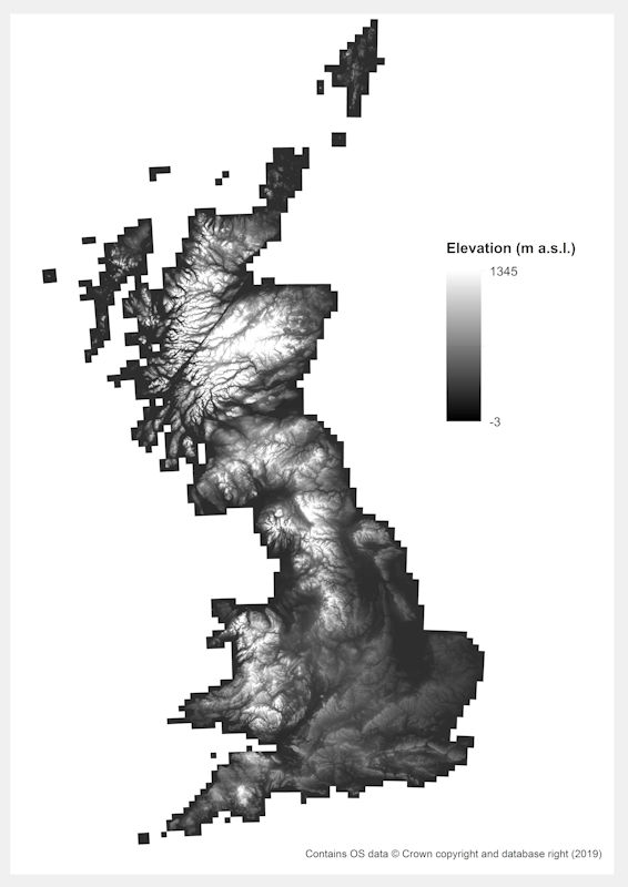
| Title | OS Terrain 50 - Elevation |
|---|---|
| Source | Ordnance Survey & terrain analysis software |
| Enquiries | https://www.ordnancesurvey.co.uk/... |
| Scale(s) | 50m grid resolution |
| Coverage | Great Britain |
| Format | ASCII grid data |
| Price | Free for use through OS OpenData |
| Uses | Local to national level use |
| UKSO map viewer | View in UKSO Map Viewer |
| WMS | https://map.bgs.ac.uk/... |
| Image(s) | High resolution |
Surface slope describes the local slope angle of any given location across a terrain surface. Each slope value is provided in degrees. The steepness of the surface is an important consideration when assessing which machinery can be used in an area, identifying areas which are more susceptible to surface runoff and even for identifying the potential of a site for renewable energy production. The slope of the surface also affects many soil characteristics particularly drainage and creep.
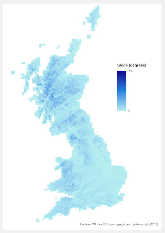
| Title | OS Terrain 50 - Slope |
|---|---|
| Source | Ordnance Survey & terrain analysis software |
| Enquiries | https://www.ordnancesurvey.co.uk/... |
| Scale(s) | 50m grid resolution |
| Coverage | Great Britain |
| Format | ASCII grid data |
| Price | Free for use through OS OpenData |
| Uses | Local to national level use |
| UKSO map viewer | View in UKSO Map Viewer |
| WMS | https://map.bgs.ac.uk/... |
| Image(s) | High resolution |
As of January 1st 2020, new regulations outlined in the Welsh Government Agricultural Pollution Measures document state that risk maps must be created for each field within a holding which, amongst other factors, should identify "land with an incline greater than 12°".
This specific dataset displays areas where the 12 degree threshold is exceeded based on a 50m resolution elevation dataset. Areas below the threshold are left transparent. As the elevation map on which the slope information has been calculated is relatively coarse.
IMPORTANT: the slope angle information provided here must only be used as a preliminary guide – local variations in slope may differ to the values captured here.
Contains OS data © Crown copyright and database right 2018
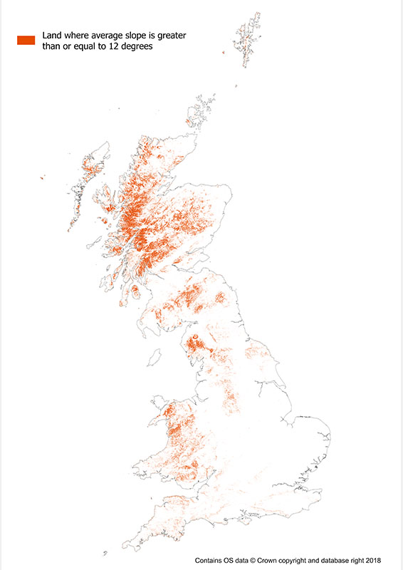
| Title | Surface slope (12 degree threshold) |
|---|---|
| Source | British Geological Survey |
| Enquiries | enquiries@bgs.ac.uk |
| Scale(s) | 1:50 000 and 50m grid resolution |
| Coverage | Great Britain |
| Format | GIS raster data. (ESRI, MapInfo, others available by request) |
| Price | Free for use through OS OpenData |
| Uses | Local to national level use |
| UKSO map viewer | View in UKSO Map Viewer |
| WMS | https://map.bgs.ac.uk/... |
| Image(s) | High resolution | Low resolution |
Surface aspect describes which direction a surface faces. Each aspect value is provided in degrees relative to grid North. The aspect of a surface has particular relevance when considering how shaded an area is likely to be and can be used to assess which areas are more likely to be wet or dry based on evapotranspiration (independent of the geology or soil characteristics). It is also an important consideration when assessing the suitability of a site for renewable energy production.
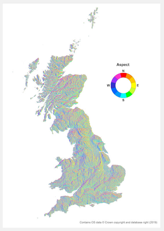
| Title | OS Terrain 50 - Aspect |
|---|---|
| Source | Ordnance Survey & terrain analysis software |
| Enquiries | https://www.ordnancesurvey.co.uk/... |
| Scale(s) | 50m grid resolution |
| Coverage | Great Britain |
| Format | ASCII grid data |
| Price | Free for use through OS OpenData |
| Uses | Local to national level use |
| UKSO map viewer | View in UKSO Map Viewer |
| WMS | https://map.bgs.ac.uk/... |
| Image(s) | High resolution |
Surface hillshade represents the amount of shading received by a surface based on time specific solar angles (azimuth and elevation). This is also affected by the slope and aspect of the terrain. Knowing which areas are more shaded is important when considering which areas will receive more sunlight throughout the day which can inform decisions on where to plant specific types of crops, assessing which surfaces are likely to remain wetter/drier (based on evapotranspiration) or cooler/warmer (independent of the geology or soil characteristics). The hillshade surface presented here was calculated using solar azimuth and elevation angles of 315° and 45° respectively.
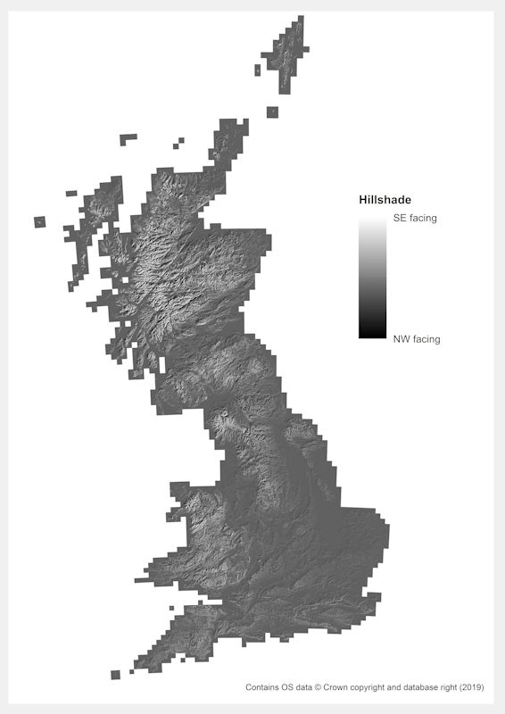
| Title | OS Terrain 50 - Hillshade |
|---|---|
| Source | Ordnance Survey & terrain analysis software |
| Enquiries | https://www.ordnancesurvey.co.uk/... |
| Scale(s) | 50m grid resolution |
| Coverage | Great Britain |
| Format | ASCII grid data |
| Price | Free for use through OS OpenData |
| Uses | Local to national level use |
| UKSO map viewer | View in UKSO Map Viewer |
| WMS | https://map.bgs.ac.uk/... |
| Image(s) | High resolution |
Terrain ruggedness represents how rough the surface terrain is and provides a means of classifying how homogenous the terrain relative to its surroundings, ranging from being level and homogenous (values closer to zero) to extremely rugged and therefore heterogeneous (larger values). Terrain ruggedness and how it changes across an area can be useful to assess how accessible a piece of land is for certain practises and for assessing land suitability for different applications.
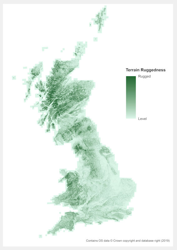
| Title | OS Terrain 50 - Terrain ruggedness |
|---|---|
| Source | Ordnance Survey & terrain analysis software |
| Enquiries | https://www.ordnancesurvey.co.uk/... |
| Scale(s) | 50m grid resolution |
| Coverage | Great Britain |
| Format | ASCII grid data |
| Price | Free for use through OS OpenData |
| Uses | Local to national level use |
| UKSO map viewer | View in UKSO Map Viewer |
| WMS | https://map.bgs.ac.uk/... |
| Image(s) | High resolution |
The surface curvature describes the degree of concavity/ convexity of the terrain. General curvature is a combination of Plan and Profile curvature, therefore relating to the curvature both parallel (along) and perpendicular (across) to a sloping surface (+ve = convex, -ve = concave). Knowing which areas are particularly concave/convex can assist in planning where to use specific types of machinery and where issues such as trailer hitching are more likely a risk. Curvature also affects soil characteristics related to drainage, accumulation and insolation.

| Title | OS Terrain 50 - General curvature |
|---|---|
| Source | Ordnance Survey & terrain analysis software |
| Enquiries | https://www.ordnancesurvey.co.uk/... |
| Scale(s) | 50m grid resolution |
| Coverage | Great Britain |
| Format | ASCII grid data |
| Price | Free for use through OS OpenData |
| Uses | Local to national level use |
| UKSO map viewer | View in UKSO Map Viewer |
| WMS | https://map.bgs.ac.uk/... |
| Image(s) | High resolution |
The surface curvature describes the degree of concavity/ convexity of the terrain. Plan curvature specifically relates to the curvature perpendicular to/across a sloping surface (+ve = convex, -ve = concave). Knowing which areas are particularly concave/convex can assist in planning where to use specific types of machinery and where issues such as trailer hitching are more likely a risk. Curvature also affects soil characteristics related to drainage, accumulation and insolation.

| Title | OS Terrain 50 - Plan curvature |
|---|---|
| Source | Ordnance Survey & terrain analysis software |
| Enquiries | https://www.ordnancesurvey.co.uk/... |
| Scale(s) | 50m grid resolution |
| Coverage | Great Britain |
| Format | ASCII grid data |
| Price | Free for use through OS OpenData |
| Uses | Local to national level use |
| UKSO map viewer | View in UKSO Map Viewer |
| WMS | https://map.bgs.ac.uk/... |
| Image(s) | High resolution |
The surface curvature describes the degree of concavity/ convexity of the terrain. Profile curvature specifically relates to the curvature parallel to/along a sloping surface (+ve = convex, -ve = concave). Knowing which areas are particularly concave/convex can assist in planning where to use specific types of machinery and where issues such as trailer hitching are more likely a risk. Curvature also affects soil characteristics related to drainage, accumulation and insolation.
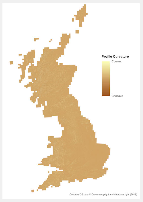
| Title | OS Terrain 50 - Profile curvature |
|---|---|
| Source | Ordnance Survey & terrain analysis software |
| Enquiries | https://www.ordnancesurvey.co.uk/... |
| Scale(s) | 50m grid resolution |
| Coverage | Great Britain |
| Format | ASCII grid data |
| Price | Free for use through OS OpenData |
| Uses | Local to national level use |
| UKSO map viewer | View in UKSO Map Viewer |
| WMS | https://map.bgs.ac.uk/... |
| Image(s) | High resolution |