We have been monitoring soils since the beginning of the last century, with many years of research experience, collecting tens of thousands of soil samples and performing hundreds of different analytical methods. This represents millions of pounds of research investment and has created a powerful data resource for soil research in the United Kingdom and Europe. We are all working to make more of our datasets readily visible and accessible through the UKSO and will be adding further downloadable data content as it becomes available.
We encourage everyone to explore the research materials available on the UKSO. Contact us if you create something new and innovative that could benefit others.
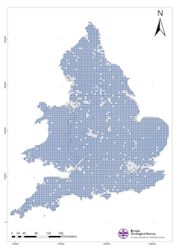
The National Soil Inventory (NSI) is a set of soil samples at a density of one sample per 25km2 collected across England and Wales. The original sample programme during the 1980s, and subsequent partial re-sampling programme during the 1990s, provide a status, stock and change assessment of key soil properties such as pH and key chemical elements. The data are held and maintained by the National Soil Resources Institute (Cranfield University).
In a joint project between BGS and Rothamsted Research this dataset was re-analysed for 50 elements. The interpolated maps for these elements are available in the UKSO map viewer.
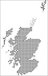
The National Soil Inventory of Scotland (NSIS) is a set of soil samples at a density of 1 sample per 25km2 collected across Scotland. The original sample programme (during the 1970's and 1980's), and subsequent resampling programme (from 2007 - 2010) provide a status, stock and change assessment of key soil properties (such as nutrient levels).
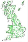
The Countryside Survey Soil data has been collected over three surveys: 1978, 1998 and 2007. Samples are collected from 591 (1km2) squares across Great Britain. Data are available on the total stock and inter-survey change of a wide range of soil attributes including soil carbon, nutrients, heavy metals and invertebrates.
Both summary and raw data by country, broad habitat, vegetation type, and soil organic matter category can be downloaded from Countryside Survey data access. You will need to become a registered user to access their data.
Selected interpolated maps for these elements are available in the UKSO map viewer.
* Please note that available data does not contain spatial coordinates for Countryside Survey sampling locations as they are based on anonymous site-survey protocols.
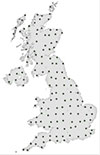
The Geochemical Mapping of Agricultural Soils in Europe (GEMAS) project collected soil samples during 2008 at a density of 1 site per 2500km2 from grazing and arable fields across the UK. Data are available on a wide range of characteristics including total C and S, total organic carbon (TOC), cation exchange capacity (CEC), XRF analysis of multiple elements, pH, and particle size distribution (PSD) analysis.
The data has been reported, further information can also be obtained from the GEMAS UK partner.
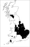
The Geochemical Baseline Survey of the Environment (G-BASE) project has collected samples at a density of one sample per 2km2 from rural environments across parts of Great Britain, and at a density of four sites per 1km2 within the build-up areas of 25 major cities . Soils were sampled by multiple campaigns between 1985 and 2013 (older samples from previous reconnaissance projects are also available). Each site has a surface sample (5-20cm) and a profile sample (35-50cm). A third topsoil sample (0-2cm) was also collected across Greater London. For each sample, a suite of over 50 elements have been analysed.
High density soil geochemical data are also available for 25 major cities and towns of Great Britain. Soil samples were collected as part of the Geochemical Baseline Survey of the Environment (G-BASE) project at a density of four sites per 1km2 within the build-up areas. At each sampling site a surface (5-20cm) and a profile (35-50cm) sample were collected (and a third topsoil sample from 0-2cm across Greater London).
The data are held and maintained by the British Geological Survey. Final analyses from summer 2013 sampling will be available from summer 2016.
Observatories
Observatories and long term monitoring sites play a vital role in our current research of soils across the UK. Numerous observatories (and networks of observatories) are currently managed by UKSO partners. If you are a researcher working on an observatory site (or network) and wish to add further information, links or new sites to this page, then please contact us.
Plynlimon observatory
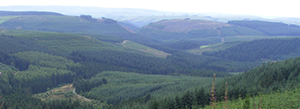
The Plynlimon experimental catchments, which cover a combined area of 19.25km2, are located on the east flanks of Plynlimon, approximately 20 km inland of Aberystwyth on the mid-Wales coast. The site is used for intensive and long-term monitoring that underpins a wealth of hydrological and hydrochemical research. Monitoring is funded by the Centre for Ecology & Hydrology (CEH) and has been in progress since 1968. The combined temporal datasets include river flow, rainfall, cloud and stream hydrochemistr, meteorology, and a variety of spatial datasets representing the topography, soils and rivers of the catchments. To access the datasets, please go to the CEH Environmental Information Platform and search for Plynlimon.
The CEH carbon catchments are a network of four UK peatland sites (Forsinard, Auchencorth Moss, Moor House and Conwy) that aim to quantify the overall carbon balance of individual peatlands by measuring and combining various flux terms. This involves linking long-term measurements of land–atmosphere carbon flux (CO22 and CH4) to downstream fluxes of particulate, dissolved and gaseous forms of carbon in rivers. The carbon balances of individual peatlands are based on high quality, reliable flux data, leading to an empirical understanding of the factors controlling these fluxes.
The UK Environmental Change Network (ECN) terrestrial sites are part of a long-term (20 year) environmental monitoring programme. Temporal data is collected, analysed and interpreted from a network of 12 terrestrial sites. The physical, chemical and biological data are a unique national resource that is improving our understanding of how and why environments change. Data from the ECN can be downloaded from the dedicated ECN datacentre.
The National Soil Moisture Network (COSMOS-UK) is establishing the first UK large area soil moisture network. The network delivers exciting new data showing how soil moisture varies across the country with soil type, climate and vegetation. COSMOS-UK stations also measure the weather and other environmental variables.
Our Welsh long-term climate change monitoring site has the longest data stream for responses of carbon fluxes and biodiversity to continuous manipulation of precipitation and air temperature in the UK. Our site is located in the Conwy landscape and is capturing the effects of drought and warming on an upland heath vegetation on organo-mineral soil. Our monitoring site is part of a cross European climate change network and facilitates EU trans-national access. We measure climate induced changes as anticipated in a future climate in the soil-atmosphere continuum (e.g. greenhouse gas fluxes) and created long-term air and soil temperature and soil moisture records that are now available in real time.
Cranfield's soil bin
The rainfall simulation laboratory includes a selection of pressurised and gravity-fed rainfall simulators that enable accurate simulation of temperate and tropical rainfall, drop size, intensities and kinetic energy conditions over a range of return period storm events. As well as undertaking fundamental research into erosion processes and leaching studies at a sub-process level, the erosion laboratory is ideal for evaluating the comparative erodibility of slope forming materials (including soil, waste rock and ores). A comprehensive range of erosion control technologies can be tested using slope adjustable (0–45°) runoff rigs with 1m x 2m test surfaces and a comprehensive range of experimental trays, all with the capacity for collection of surface runoff, leachate and particulates. In addition, there are a variety of modular (up to 6m x 2m) and single post, pressure-fed rainfall simulators for field-based testing in a range of different terrains and situations. Equipment is available to establish and remotely monitor large scale field plots on a range of cropping systems and engineered slopes. The laboratory recently featured in an article on soil management and flooding by the BBC.
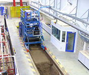
The soil lane is designed for whole vehicle testing. It is 45m long, 5m wide and 0.75m to 2m deep, with a subsurface irrigation/drainage system for soil moisture control. Substrate (sand or soil) is prepared in situ against a reference plan in a controlled and repeatable manner.
The soil bin is a 20m long, 1.7m wide and 0.7m deep soil dynamics facility that can be prepared in layers to create a number of highly controlled and repeatable test profile conditions. The soil bin processor has instrumented mounting points for the testing of cultivation implements, tyres and sensors, and an infinitely variable drive system to allow for both low and high speed testing. The facility can also be used to determine draught and vertical force requirements and tillage efficiency.
North Wyke observatory
The Long Term Experiments National Capability, including long-term experiments, sample archive and e-RA database, comprise a unique, 170 year old experimental system and sample and data archive funded by the BBSRC as a National Capability. There are simple to use online tools to view and download data from the archive, for example the Broadbalk and Hoosfield Soil Organic Carbon datasets, which are available as open access datasets.
The North Wyke farm platform is a BBSRC-funded National Capability for agri-environmental research into beef and sheep production on lowland grassland systems that comprises fully instrumented, hydrologically isolated and separately managed farmlets.
The UK Environmental Change Network (ECN) terrestrial sites are part of a long-term (20 year) environmental monitoring programme. Temporal data is collected, analysed and interpreted from a network of 12 terrestrial sites. The physical, chemical and biological data are a unique national resource that is improving our understanding of how and why environments change. Data from the ECN can be downloaded from the dedicated ECN datacentre.
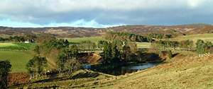
Glensaugh observatory
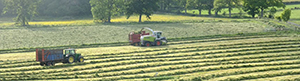
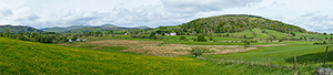
Balruddery Farm is an 170 hectare (ha) arable farm located seven miles west of Dundee and between 70m and 124m above sea level on the lower slopes of the Sidlaw Hills. It is the site of the Centre for Sustainable Cropping and also where our annual field event Potatoes in Practice is held.
Glensaugh research station extends to 1000ha and lies in the Grampian foothills to the east of the B974 Fettercairn to Banchory road, about 7km north of Laurencekirk. Glensaugh continues to be available for outdoor experiments from plot to field right up to landscape scale. Indoor facilities include metabolism rooms, calorimeter chambers and a suite of laboratories. Glensaugh Research Station is one of the 11 UK sites in the Environmental Change Network (ECN). Measurements are being made of the long-term changes in dry and wet aerial deposition, water quality, soil characteristics, vegetation and wildlife. The ECN is sponsored by several UK government departments and agencies and the Scottish Government and its agencies. Read more on the automatic weather station and Birnie Burn environmental monitoring pages.
Hartwood research station is located near Shotts in Lanarkshire. The area is mainly upland farms devoted to stock rearing. Hartwood covers 350ha, most of which slopes gently southwards, rising from 150m to 300m above sea level. Research projects are concerned with the development of sustainable management systems to meet agricultural and environmental objectives. Also under way are long-term experiments to examine the effects on grassland when sewage is applied, specifically on the effects on the distribution of endocrine disrupting chemicals in soils, herbage and sheep; and on the impact of sewage-borne heavy metals on the soil.
River Eden demonstration test catchment
The Hollin Hill landslide observatory is located in Yorkshire, England. The site captures real time weather and soil geophysics data to monitor a range of soil and geology parameters relating to a small active landslip. The data from the ALERT system will be made available as a live stream on this website in the near future.
The Shelford earth observatory is predominantly used for arable agriculture and covers an area of about 1.5km2 close to the village of Shelford, near Radcliffe-on-Trent, Nottinghamshire. The site is currently being used as a basis of several studies as it offers an excellent opportunity to study shallow groundwater alluvial/terrace soil interactions in an area liable to flooding.
The River Eden demonstration test catchment (EdenDTC) is a Defra funded research project in the Vale of Eden near Penrith, Cumbria, England. The aim of the project is to assess if it is possible to cost effectively mitigate diffuse pollution from agriculture whilst maintaining agricultural productivity. Data analysis includes a range of soil management interventions linked to water quantity and quality monitoring.