Select an option from the list below to view high resolution images and data about the World reference base.
The World Reference Base for Soil Resources (WRB) maps have been developed for Scotland by the James Hutton Institute, for England and Wales by the National Soil Resources Institute and for Northern Ireland by the Agri-Food and Biosciences Institute.
The WRB mapping provides a baseline soil map layer for Great Britain. The maps are presented at a nominal scale of 1:1 million, and are derived from the 1:250 000 scale national maps from the above institutions. The maps describe key characteristics of British soils using a harmonised soil taxonomy for the world, developed by an international collaboration co-ordinated by the International Soil Reference and Information Centre (ISRIC).
In order to generate a soil map of Scotland using the World Reference Base (WRB) soil classification system, the dominant soil taxonomic unit in each 1:250 000 scale soil map units were classified according to the diagnostic criteria laid out in WRB 2007 (IUSS Working Group WRB, 2007) and following the updated procedures for constructing small scale map legends (IUSS Working Group WRB, 2010). As the intention was to produce a map at a notional scale of 1:1 000 000, the soils were classified to the level of the reference soil group and two qualifiers.
A set of rules were devised and applied to the dominant soil type in each of the 580 soil map units of the 1:250 000 scale national soil map of Scotland (Soil Survey of Scotland Staff, 1981), for each of the broad land use phases (cultivated or uncultivated) where appropriate, and using the summary analytical data contained within the SSKIB database. The rules for identifying reference soil groups, diagnostic criteria and diagnostic horizons are listed in the GS soil report (Hudson et al., 2012). The rules were implemented with a Microsoft Access database wherever possible, with some manual checking and updating. Additional information such as the HOST classification (Boorman, Hollis, and Lilly, 1995) was used to provide additional information on soil wetness (colour pattern, gley and stagnic properties) as the soil morphological information required to classify soils according to WRB (such as stagnic or gleyic colour patterns and horizon permeability) had already been determined and was not part of the SSKIB database. Chemical, texture or horizon type data were taken where required from SSKIB and therefore are median values for the specific property. The application of these rules to the dominant soil series (for both cultivated and uncultivated phases in each of the 1:250 000 scale map units) resulted in 75 unique WRB classes.
Boorman, D B, Hollis, J M and Lilly, A. 1995. Hydrology of soil types: a hydrologically-based classification of the soils of the United Kingdom. Institute of Hydrology Report No.126. Institute of Hydrology, Wallingford.
Hudson, G et al. 2012. Harmonisation of 1:250 000 scale soil maps and soil profile data in the Celtic fringe of Europe: Scotland, Northern Ireland and Eire. Test case report. D4.3 Data Harmonization Best Practice Guidelines, GS Soil Final Report to the European Commission.
ECP-2008-GEO-318004IUSS Working Group WRB. 2007. World Reference Base for Soil Resources 2006, first update 2007. World Soil Resources Reports No. 103. FAO, Rome.
IUSS Working Group WRB. 2010. Addendum to the World Reference Base for Soil Resources: Guidelines for constructing small-scale map legends using the World Reference Base for Soil Resources. FAO, Rome.
* Soil Survey of Scotland Staff. 1981. Soil maps of Scotland at a scale of 1:250 000. Macaulay Institute for Soil Research, Aberdeen.
* Please cite as: Lilly, A, Baggaley, N, Donnelly, D. 2012. Map of Soils World Reference Base of Scotland. Map prepared for EU project GS-SOIL -Assessment and strategic development of INSPIRE compliant Geodata-Services for European Soil Data. ECP-2008-GEO-318004.
These data are delivered under the terms of the Open Government Licence, subject to the following acknowledgement accompanying the reproduced James Hutton Institute materials: "Contains James Hutton Institute materials © 2014".
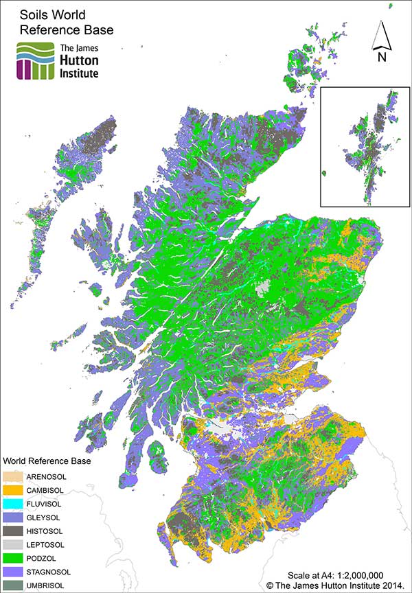
| Title | The soils of Scotland in the WRB classification system |
|---|---|
| Source | The James Hutton Institute |
| Enquiries | info@hutton.ac.uk |
| Scale(s) | 1:250 000 |
| Coverage | Scotland |
| Format | GIS polygon data (ESRI, others available by request) |
| Price | Data can be downloaded for free under an Open Data licence from Scotland's soils website |
| Uses | Local to national level use |
| Map Viewer | View in UKSO Map Viewer |
| WMS link | http://druid.hutton.ac.uk/... |
| Images | High resolution | low resolution |
The World Reference Base map for England and Wales is derived from the national soil map at 1:250 000 scale for England and Wales, showing the locations of 13 distinct reference soil groups recognised in England and Wales. The dominant soil series in each soil association has been classified to show the equivalent soil class to Level 1 Soil Group in the World Reference Base classification system of 2006 as defined in World Soil Resources reports No. 103.
The information contained in LandIS is copyrighted and its use is subject to a specific licensing agreement between Cranfield University and the user. Depending on the status of the user, the cost can vary from a fully commercial charge for data lease to being royalty-free with a small charge for extraction and preparation of the data to meet the user's needs.
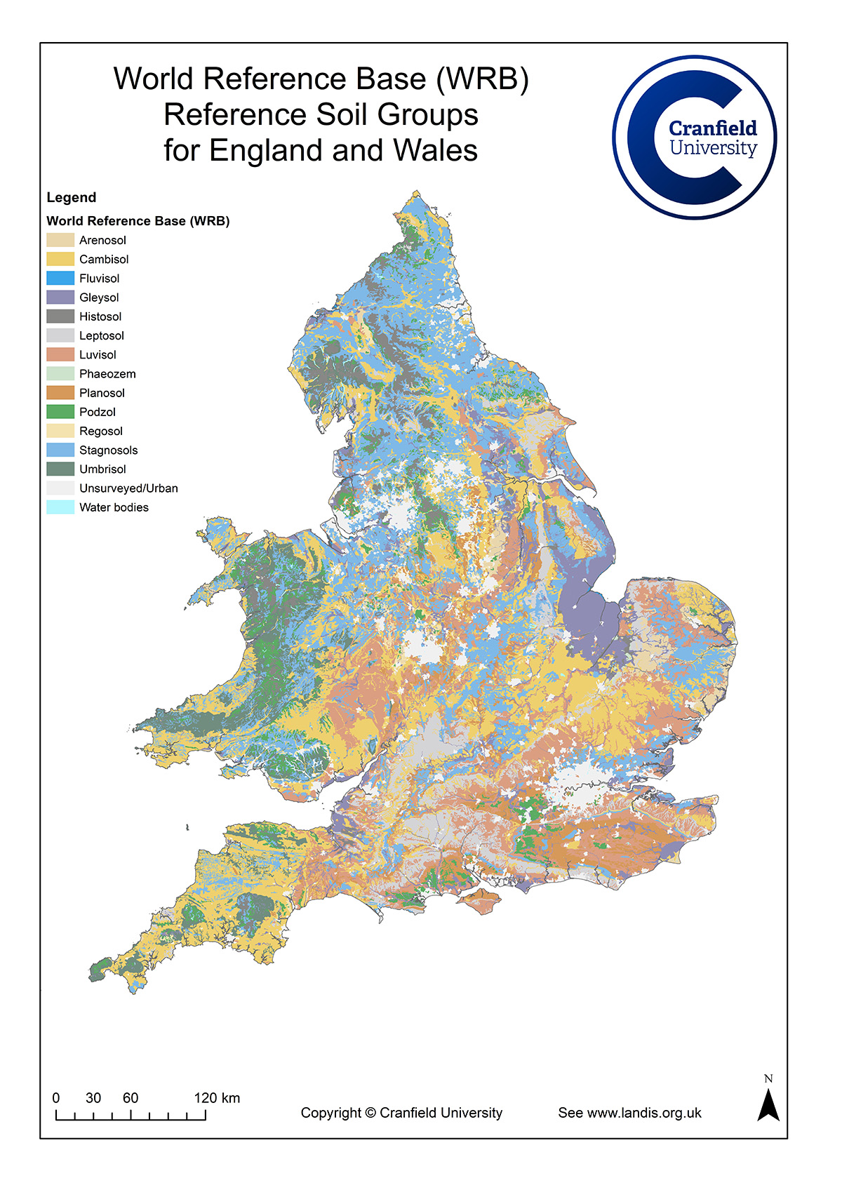
| Title | Soil map for England and Wales — WRB 2006 tier 1 version |
|---|---|
| Source | Cranfield National Soil Resources Institute (NSRI), Cranfield University |
| Enquiries | nsridata@cranfield.ac.uk |
| Scale(s) | 1:250 000 |
| Coverage | England and Wales |
| Format | GIS polygon data (ESRI, others available by request) |
| Price | For licensing data and prices please see http://www.landis.org.uk/... |
| Uses | Local to national level use |
| Map Viewer | View in UKSO Map Viewer |
| WMS link | http://www.landis.org.uk/... |
| Images | High resolution | low resolution |
The World Reference Base map shows the locations of the nine reference soil groups recognised in Northern Ireland. It is derived from the General Soil Map of Northern Ireland at 1:250 000 scale, held by the Agri-Food and Biosciences Institute (AFBI). The dominant soil series in each soil group has been correlated to the equivalent Tier 1 Reference Soil Group in the World Reference Base classification system of 2006 as defined in World Soil Resources reports No. 103.
The Soil Map for Northern Ireland — World Reference Base (WRB) 2006 Tier 1 Version is protected by copyright and its use is subject to a specific licensing agreement between AFBI and the user. Depending on the status of the user, the cost can vary from a fully commercial charge for data lease to being royalty free with a small charge for extraction and preparation of the data to meet the user's needs.
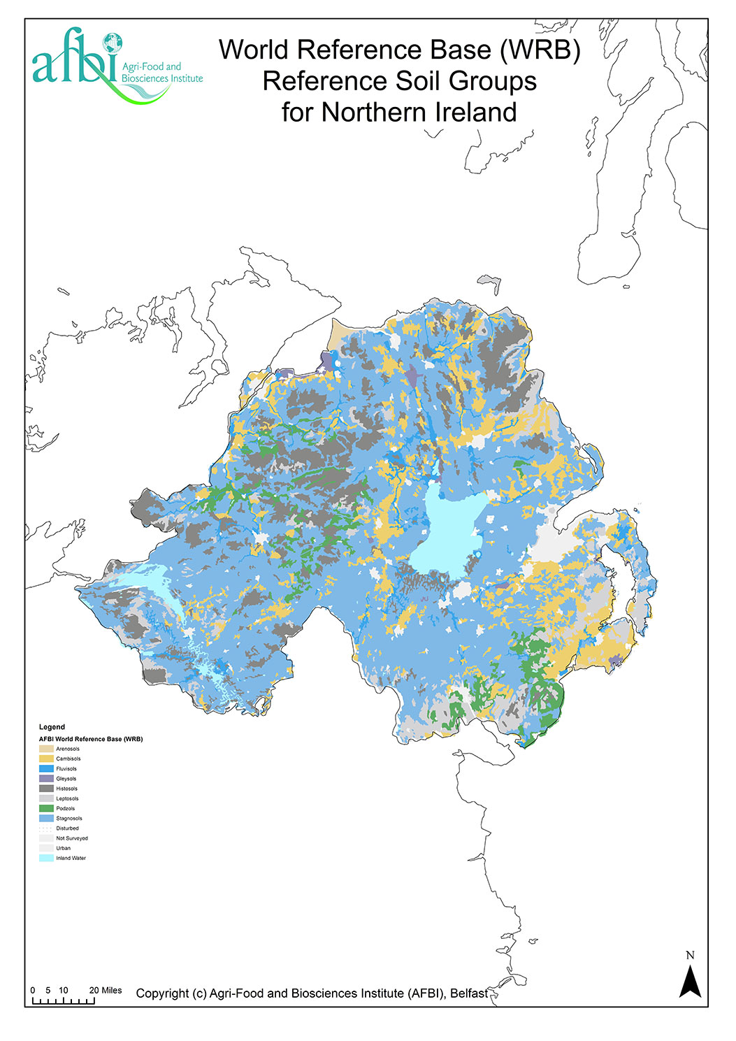
| Title | Soil map for Northern Ireland — WRB 2006 tier 1 version |
|---|---|
| Source | Agri-Food and Biosciences Institute (AFBI) |
| Enquiries | info@afbi.gov.uk |
| Scale(s) | 1:250 000 |
| Coverage | Northern Ireland |
| Format | GIS polygon data (ESRI, others available by request) |
| Price | For licensing data and prices please email AFBI |
| Uses | Local to national level use |
| Map Viewer | View in UKSO Map Viewer |
| WMS link | http://www.landis.org.uk/... |
| Images | High resolution | low resolution |