Select an option from the list below to view high resolution images and data about soils across England and Wales.
The national soil and soil properties maps for England and Wales have been developed by the National Soil Resources Institute (NSRI). The maps include the 1:250 000 scale Soilscapes, developed from the more detailed national soil map (NATMAPvector) and a series of thematic soil properties including carbon, metal binding capacity and native woodland models. These maps are developed with the purpose of effectively communicating a general understanding of the variations that occur between soil types and how soils affect the environment. Soil significantly influences our whole ecosystem and is a fragile resource that needs to be understood and protected.
LandIS information is copyrighted, its use is subject to a licensing agreement between Cranfield University and the user. Cost can vary from a fully commercial charge for data lease to being royalty-free with a small charge for extraction and preparation of the data to meet the user's needs.
Soilscapes is a 1:250 000 scale, simplified soils dataset covering England and Wales. It was created from the far more detailed national soil map (NATMAP Vector) held by the National Soil Resources Institute (NSRI) at Cranfield University, with the purpose of communicating a general understanding of the variations that occur between soil types, and how soils affect the environment and landscape of the two countries. Soil exerts a strong influence on our whole ecosystem, being the foundation for many of the ecosystem services and functions, and is a fragile resource that needs to be understood and protected.
For more information on the classification check out the Soils Guide, or view within Cranfield's online Soilscapes Viewer.
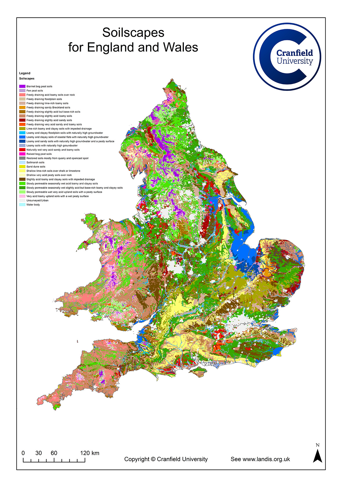
| Title | Soilscapes for England and Wales |
|---|---|
| Source | Cranfield National Soil Resources Institute (NSRI), Cranfield University |
| Enquiries | nsridata@cranfield.ac.uk |
| Scale(s) | 1:250 000 |
| Coverage | England and Wales |
| Format | GIS polygon data. (ESRI, MapInfo, other formats available by request) |
| Price | For licensing data and prices please see http://www.landis.org.uk/... |
| Uses | Regional to national level use |
| Downloads | User guide |
| Map Viewer | View in UKSO Map Viewer |
| WMS link | http://www.landis.org.uk/... |
| Images | High resolution | low resolution |
The objective of the model is to assess the metal binding capacity of different soils for different metals and is based on the approach from Blume and Brümmer (1991). The methodology is based on a weighted parametric classification and consists of a series of lookup tables that allows the user to 'score' a number of soil attributes and to ultimately arrive at a total score. This total score is then translated into a textual description of relative binding class; six classes have been identified ranging from very strong to no binding capacity.
For more information on the cadmium sesquioxide metal binding capacity model, refer to http://www.landis.org.uk/...
Blume, H P and Brümmer, G. 1991. Prediction of heavy metal behaviour in soil by means of simple field tests. Ecotoxicology and Environmental Safety, 22, pp. 164–174.
Paterson, E, Towers, W, Lumsdon, D G and Meeussen, J C. 1997. Responses of Scottish soils to heavy metal inputs. Scottish Natural Heritage Review, No 61, SNH Edinburgh.
Towers, W and Paterson, E. 1997. Sewage sludge application to land — a preliminary assessment of the sensitivity of Scottish soils to heavy metal inputs. Soil Use and Management, 13(3), 149–155.
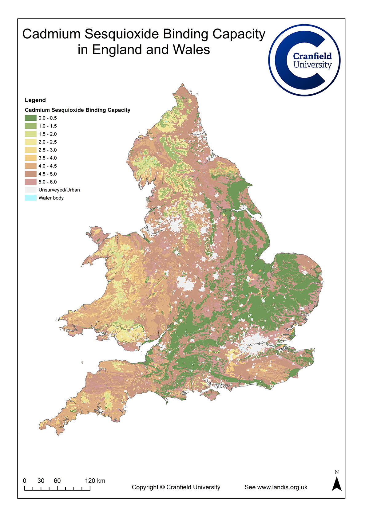
| Title | Cadmium sesquioxide metal binding capacity |
|---|---|
| Source | Cranfield National Soil Resources Institute (NSRI), Cranfield University |
| Enquiries | nsridata@cranfield.ac.uk |
| Scale(s) | 1:250 000 |
| Coverage | England and Wales |
| Format | GIS polygon data. (ESRI, MapInfo, other formats available by request) |
| Price | For licensing data and prices please see http://www.landis.org.uk/... |
| Uses | Regional to national level use |
| Map Viewer | View in UKSO Map Viewer |
| WMS link | http://www.landis.org.uk/... |
| Images | High resolution | low resolution |
The database gives soil organic carbon, sand, silt and clay contents and bulk density weighted to reference layers from 0 cm to 30 cm and from 30 cm to 100 cm depths. The data are interpolated from information on soil types and land use on a 1 km grid across the UK and are used to estimate soil carbon stocks. The objective of this research was to derive high-resolution spatial data on soil and land use data for use by dynamic simulation model of carbon fluxes from soils resulting from land use change.
The soil spatial distribution was based on the revised 1:250 000 national soil map for England and Wales, the 1:250 000 national soil map for Scotland and the 1:50 000 soil series map for Northern Ireland. Soil profile information was derived from the soil reference database and the National Soil Inventory for England and Wales, the Scottish soil database, and the attribute database of all soil horizons at 5 km inspection pits sampled as part of the Department for Agriculture and Rural Development soil survey.
For more information on the topsoil carbon stocks map, refer to http://www.landis.org.uk/...
Bradley, R I, Milne, R, Bell, J, Lilly, A, Jordan, C and Higgins, A. 2005. A soil carbon and land use database for the United Kingdom. Soil Use and Management, 21, pp. 363–369.
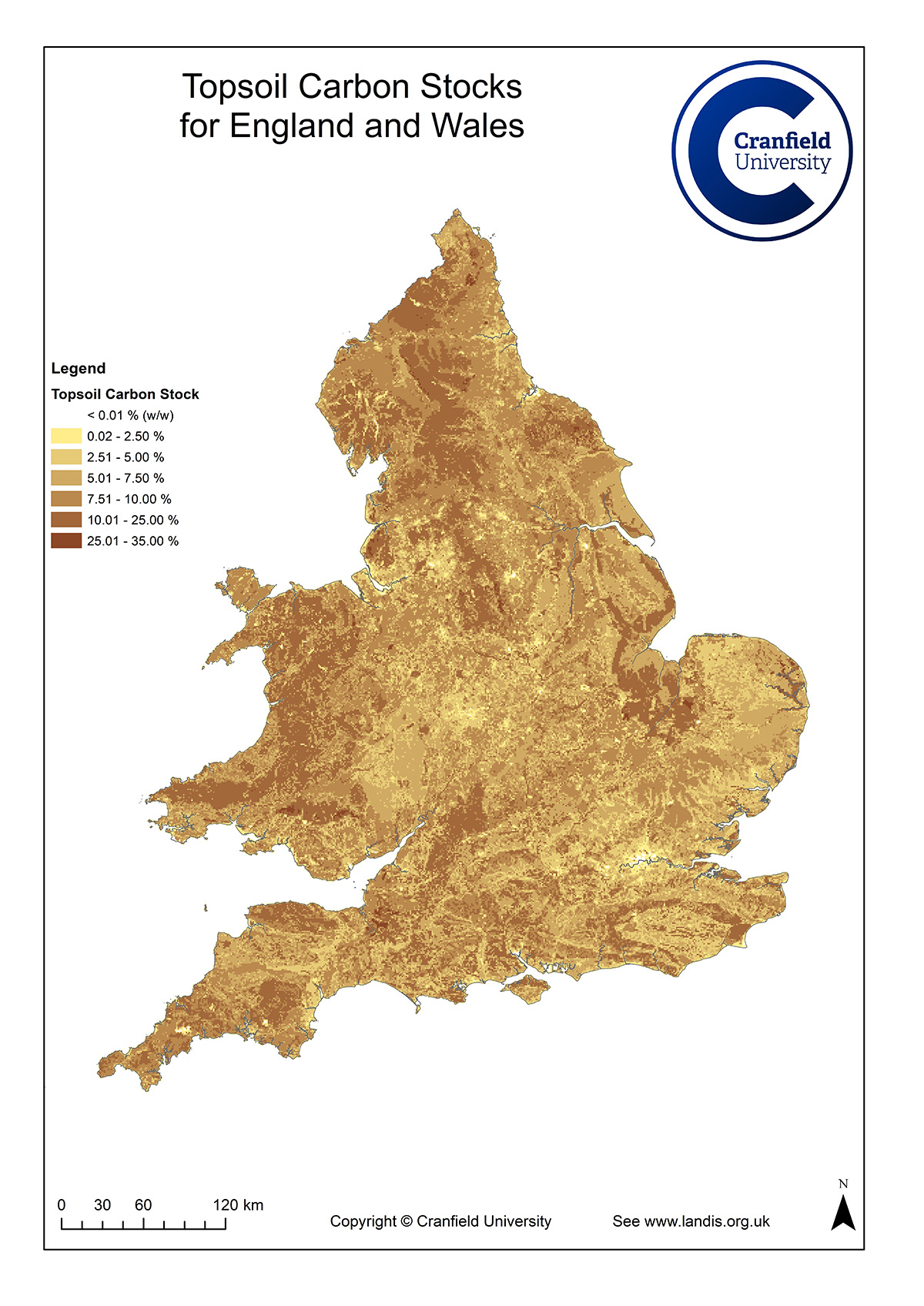
| Title | Topsoil carbon stock |
|---|---|
| Source | Cranfield National Soil Resources Institute (NSRI), Cranfield University |
| Enquiries | nsridata@cranfield.ac.uk |
| Scale(s) | 1:250 000 |
| Coverage | England and Wales |
| Format | GIS polygon data. (ESRI, MapInfo, other formats available by request) |
| Price | For licensing data and prices please see http://www.landis.org.uk/... |
| Uses | Regional to national level use |
| Map Viewer | View in UKSO Map Viewer |
| WMS link | http://www.landis.org.uk/... |
| Images | High resolution | low resolution |
An understanding of the potential of different areas within a landscape to support different woodland types is crucial to planning the restoration and expansion of native woodland. The native woodland model has been developed as a strategic tool to aid those involved in such projects, whether on currently unwooded land or in non-native forest plantations. It is suitable for use at scales above 1:50 000.
The methodology relies on the interpretation of integrated soils and land cover data in relation to the growth requirements of different woodland types. Combinations of these attributes are assessed and an optimal native woodland type is assigned to each combination. This is a very pragmatic model and uses major soil subgroups and geology (effectively soil series in a Scottish context), rather than specific attributes and thresholds. This is then qualified by land cover, which has been used to assess how the soil may or may not have been modified by human intervention. The approach might best be described as 'map unit interpretation', qualified by knowledge of current land cover (from LCS88, although LCM2000 is equally valid and possibly more so because of its currency).
For more information on the native woodland model, refer to http://www.landis.org.uk/...
Towers, W, Hester, A J, Malcolm, A, Stone, D and Gray, H. 2002. The use of soils data in natural heritage planning and management. Soil Use and Management, 18, pp. 26-33.
Hester, A J, Towers, W and Malcolm, A. 2003. Modelling the potential distribution of woodland at the landscape scale. In: The restoration of wooded landscapes (Eds. J Humphrey, A Newton, J Latham, H Gray, K Kirby, E Poulson and C Quine). Forestry Commission, Edinburgh.
Towers, W, Hester, A J, Malcolm, A, Hall, J and Stone, D. 2004. The potential for native woodland in Scotland: the native woodland model. Scottish Natural Heritage, Battleby, Perth. Natural Heritage Management Series. 56p. Includes CD ROM. ISBN 1 85397 390 4.
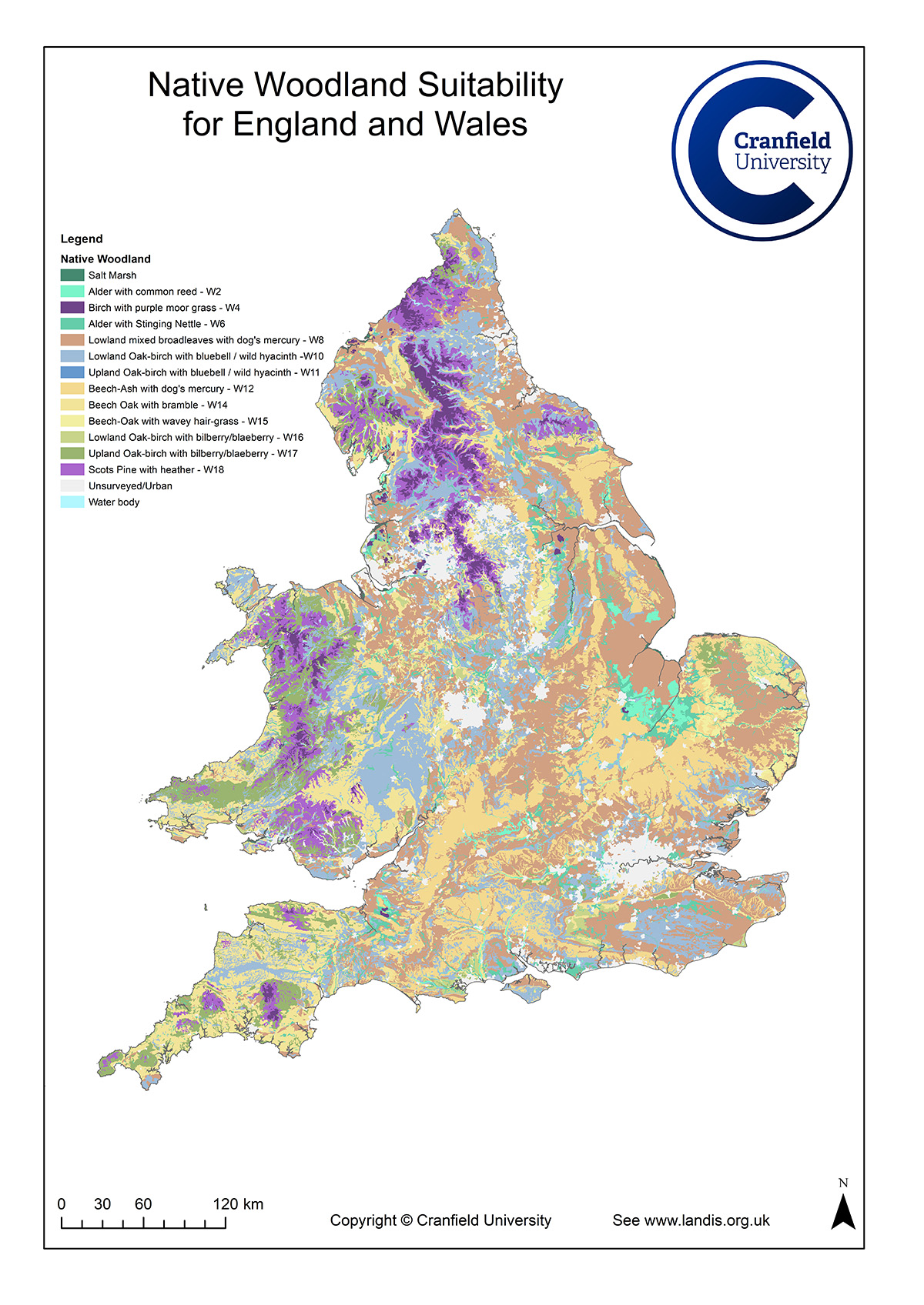
| Title | Native woodland model |
|---|---|
| Source | Cranfield National Soil Resources Institute (NSRI), Cranfield University |
| Enquiries | nsridata@cranfield.ac.uk |
| Scale(s) | 1:250 000 |
| Coverage | England and Wales |
| Format | GIS polygon data. (ESRI, MapInfo, other formats available by request) |
| Price | For licensing data and prices please see http://www.landis.org.uk/... |
| Uses | Regional to national level use |
| Map Viewer | View in UKSO Map Viewer |
| WMS link | http://www.landis.org.uk/... |
| Images | High resolution | low resolution |