Select an option from the list below to view high resolution images and data about soils across Great Britain.
The published national soil maps of England, Wales and Scotland have been created by the National Soil Resources Institute and The James Hutton Institute. These maps were derived from soil survey campaigns of various scales, carried out over several decades. Tradtionally supplied in paper-form, many of these maps are also available as digital data.
The national soil map of Scotland has been created from soil survey work undertaken between 1978 and 1981 and a simplification of more detailed mapping undertaken between 1947 and 1978. Mapping scales range from 1:25000 up to 1:250000.
The national soil map of England and Wales has been created from soil survey work undertaken between 1939 and 2006. Mapping scales range from 1:25000 up to 1:250000.
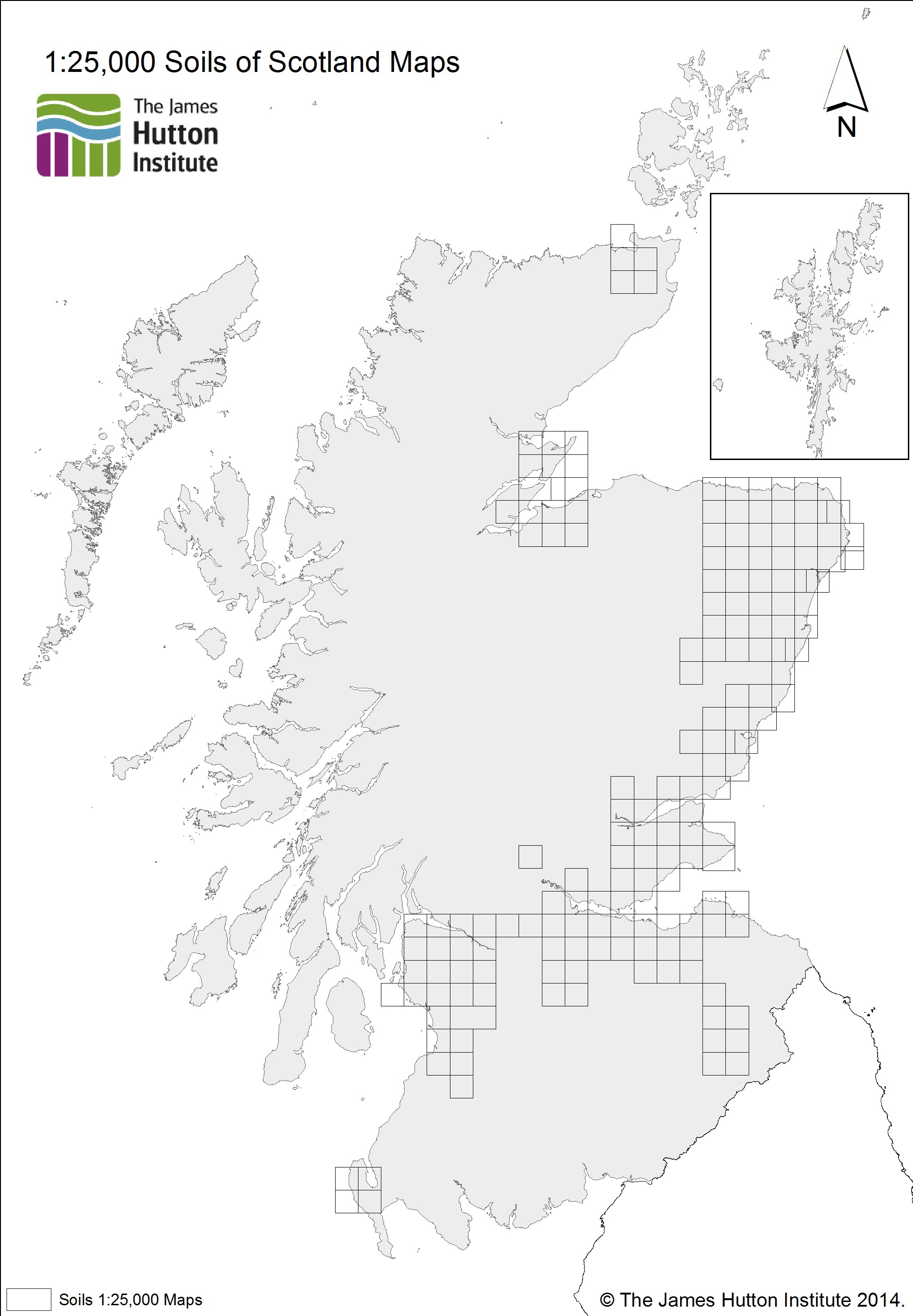
The map shows the extents of the 1:25,000 soils maps of Scotland.
Soil Survey of Scotland Staff (1970-1985). The James Hutton Institute (2014).
These data are delivered under the terms of the Open Government Licence, subject to the following acknowledgement accompanying the reproduced James Hutton Institute materials: "Contains James Hutton Institute materials © [year]".
| Title | 1:25,000 soils of Scotland |
|---|---|
| Source | The James Hutton Institute |
| Enquiries | info@hutton.ac.uk |
| Scale(s) | 1:25 000 |
| Coverage | Scotland |
| Format | GIS point data (ESRI, others available by request) |
| Price | A free WMS service is available (see below) |
| Uses | Local to national level use |
| Map Viewer | View in UKSO Map Viewer |
| WMS link | http://druid.hutton.ac.uk/... |
| Images | High resolution | low resolution |
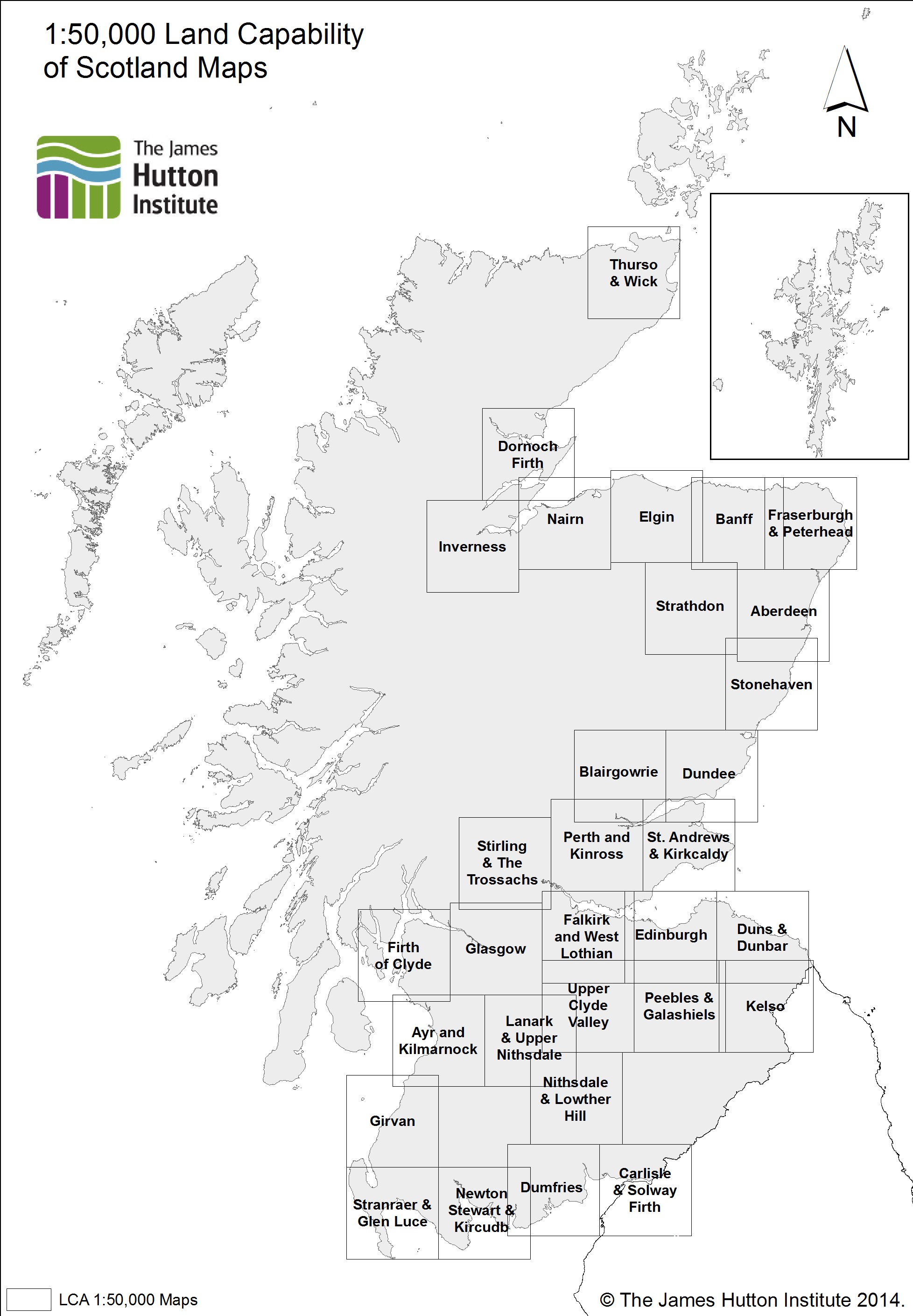
The map shows the extent of the 1:50,000 published colour land capability for agriculture maps of Scotland.
Soil Survey of Scotland Staff (1981-1988). The James Hutton Institute (2014).
These data are delivered under the terms of the Open Government Licence, subject to the following acknowledgement accompanying the reproduced James Hutton Institute materials: "Contains James Hutton Institute materials © [year]".
| Title | 1:50,000 land capability for agriculture map extents |
|---|---|
| Source | The James Hutton Institute |
| Enquiries | info@hutton.ac.uk |
| Scale(s) | 1:50 000 |
| Coverage | Scotland |
| Format | GIS point data (ESRI, others available by request) |
| Price | A free WMS service is available (see below) |
| Uses | Local to national level use |
| Map Viewer | View in UKSO Map Viewer |
| WMS link | http://druid.hutton.ac.uk/... |
| Images | High resolution | low resolution |
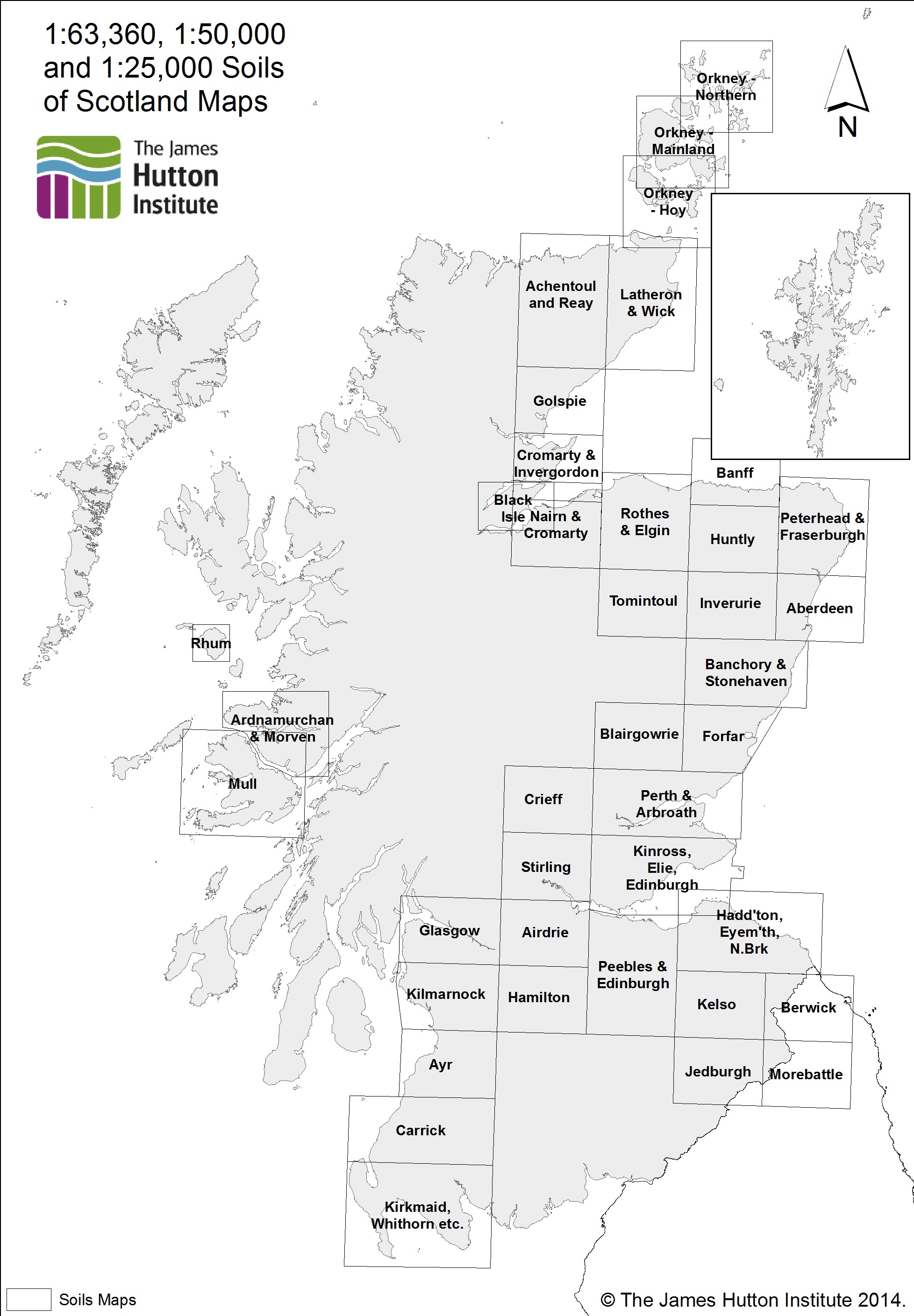
The map shows the extents of the 1:63,360, 1:50,000 1:25,000 published colour soils maps of Scotland.
Soil Survey of Scotland Staff (1981-1988). The James Hutton Institute (2014).
These data are delivered under the terms of the Open Government Licence, subject to the following acknowledgement accompanying the reproduced James Hutton Institute materials: "Contains James Hutton Institute materials © [year]".
| Title | 1:63,360 soils of Scotland map extents |
|---|---|
| Source | The James Hutton Institute |
| Enquiries | info@hutton.ac.uk |
| Scale(s) | 1:63 360 / 1:50 000 |
| Coverage | Scotland |
| Format | GIS point data (ESRI, others available by request) |
| Price | A free WMS service is available (see below) |
| Uses | Local to national level use |
| Map Viewer | View in UKSO Map Viewer |
| WMS link | http://druid.hutton.ac.uk/... |
| Images | High resolution | low resolution |
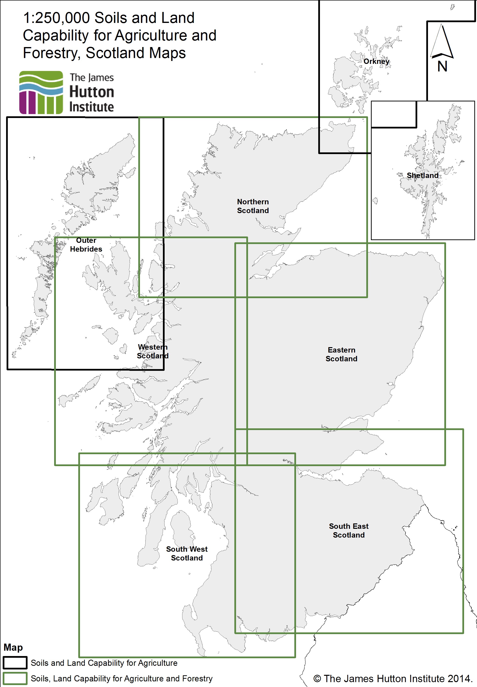
The map shows the extents of the 1:250 000 published colour soils maps of Scotland and the published land capability for agriculture and land capability for forestry maps.
Soil Survey of Scotland Staff (1981-1988). The James Hutton Institute (2014).
These data are delivered under the terms of the Open Government Licence, subject to the following acknowledgement accompanying the reproduced James Hutton Institute materials: "Contains James Hutton Institute materials © [year]".
| Title | 1:250 000 soils, land capability for agriculture and land capability for forestry map extents |
|---|---|
| Source | The James Hutton Institute |
| Enquiries | info@hutton.ac.uk |
| Scale(s) | 1:250 000 |
| Coverage | Scotland |
| Format | GIS point data (ESRI, others available by request) |
| Price | A free WMS service is available (see below) |
| Uses | Local to national level use |
| Map Viewer | View in UKSO Map Viewer |
| WMS link | http://druid.hutton.ac.uk/... |
| Images | High resolution | low resolution |
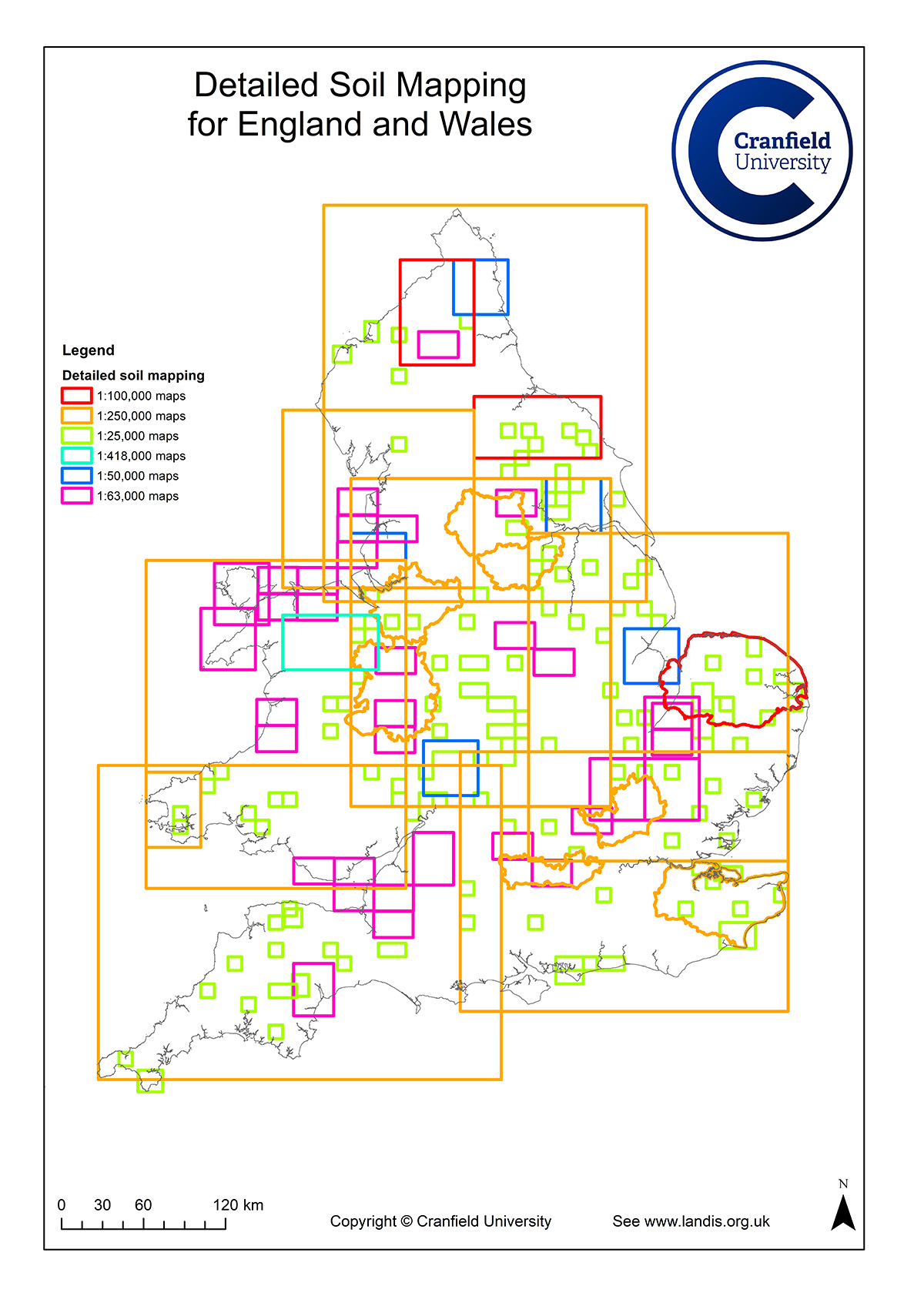
This map shows the extents of the detailed soil mapping available for a variety of scales from the National Soil Resources Institute (NSRI). These maps were conducted over three principle time periods.
From 1939 to 1966, mapping was carried out at a scale of 1:63,360 (1 inch to 1 mile). The areas mapped being selected to represent typical landscape types, soil problems, complexity of soil pattern and land use. Some 10% of England and Wales is mapped at this scale. Each map sheet covers 663 km2 and 25 of these sheets have been published
Between 1966 and 1979, mapping was carried out at 1:25,000. More than 100 of these maps have been published together with accompanying books. The distribution of the areas selected corresponds with the Ordnance Survey 10x10km 1:25,000 series. Mapping at this scale relates soil type to individual fields depicted on the base map. The choice of mapped areas was based on pedological, geomorphological and scientific agricultural interest, representing wider districts with similar environments.
The period 1983 to 1985 resulted in the publication of five 1:50,000 maps, each of 1,600 km2. The mapping procedures were similar to those used for previous local mapping. However, average density of observations was reduced proportionally. These maps were published with accompanying descriptive memoirs.
LandIS information is copyrighted, its use is subject to a licensing agreement between Cranfield University and the user. Cost can vary from a fully commercial charge for data lease to being royalty-free with a small charge for extraction and preparation of the data to meet the user's needs.
For more information on the NSRI detailed soil mapping, refer to http://www.landis.org.uk/...
| Title | NSRI detailed soil mapping |
|---|---|
| Source | Cranfield National Soil Resources Institute (NSRI), Cranfield University |
| Enquiries | nsridata@cranfield.ac.uk |
| Scale(s) | From 1:25 000 to 1:250 000 |
| Coverage | England and Wales |
| Format | GIS point data (ESRI, others available by request) |
| Price | A free WMS service is available (see below) |
| Uses | Local to national level use |
| Map Viewer | View in UKSO Map Viewer |
| WMS link | http://www.landis.org.uk/... |
| Images | High resolution | low resolution |