Select an option from the list below to view high resolution images and data about soils across Great Britain.
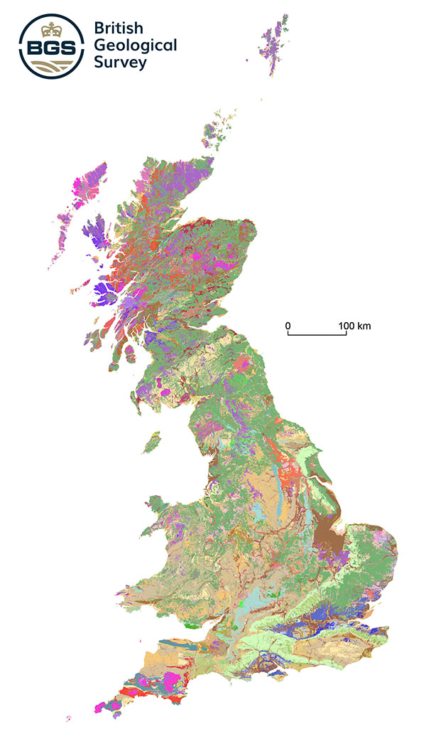
The Soil Parent Material Model was developed by the British Geological Survey (BGS). The map portrays the upper 2–3 m of the geology beneath our feet, incorporating the weathered rocks or deposits from and within which soil has formed. Parent materials frequently provide the basic foundations of soil, influencing texture, structure, drainage and chemistry.
Explore the parent materials of Britain in the UKSO map viewer and view a subset of the information available from the full Parent Material Map including European Soil Bureau parent material class, soil group, parent material grain size, soil layer thickness and soil texture.
The BGS Soil Parent Material project was set up in 2005 to create a simple, GIS-based dataset to describe the basic physical and chemical properties of parent materials. The dataset details over 30 rock and sediment characteristics including a range of texture information, colour, structure, mineralogy, lithology, carbonate content and genetic origin. It builds upon the standard DiGMapGB-50 geological dataset and is designed to be used as a framework to facilitate spatial modelling of soil properties (in conjunction with other data such as terrain, climate and land-use). The project has contributed to the creation of the mySOIL and UK Soil Observatory parent material datasets found on this website.
These data are delivered under the terms of the Open Government Licence, subject to the following acknowledgement accompanying the reproduced BGS materials: "Contains British Geological Survey materials © [year]".
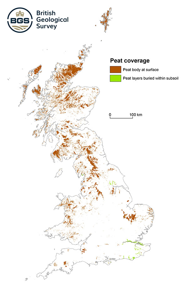
This map provides an indication of the presence of peat at a scale of 50m resolution (visible at higher zoom levels).
The map shows an overview of the published mapped peat, together with other superficial deposits with a lithological content/characteristic of peat (here peat layers are accumulated and then buried within another deposit). The data is derived from BGS Geology Surface dataset version 8.24.
Peat is usually found in boggy areas or the fens, both having distinct qualities i.e. peat formed in a boggy area tends to be acidic whereas peat in the fens is usually alkaline. Because of its high carbon content peat has for many years being used as a fuel. Its other user has been in the horticultural sector because of its rich nutrient content and water bearing properties. Now in recent years the attention on peat is now on climate change and biodiversity and its preservation.
| Title | Parent material peat coverage |
|---|---|
| Source | British Geological Survey |
| Enquiries | enquiries@bgs.ac.uk |
| Scale(s) | 1:50 000 and 1km grid resolution |
| Coverage | Great Britain |
| Format | GIS polygon data (ESRI, MapInfo, others available by request) |
| Price | We encourage users to use OpenGeoscience material with their own data |
| Uses | Local to national level use |
| Map Viewer | View in UKSO Map Viewer |
| WMS link | https://map.bgs.ac.uk/... |
| Images | High resolution |
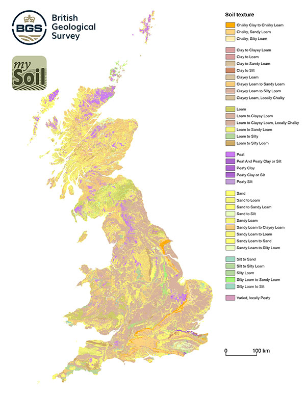
The simplified texture classifications are derived from measured soil textures (%clay, %silt and %sand) taken from archive GBASE and geotechnical samples held by BGS. The samples are compared with a simplified soil-texture triangle used for mySOIL and are grouped by their underlying soil-parent material type to show a map of distribution of the classes; expert judgment has been used to estimate a texture class where sample data is not available). Note that the map uses terms that refer to: Sandy soils, Silty soils, Clayey soils and Loamy soils with additional indicators for the presence of Chalk fragments (Chalky) and Peat (Peaty). Most parent materials generate a broad range of soil textures so these terms should be regarded as 'indicative'. Further information is available from the mySOIL resource page. The GBASE laser granulometry dataset (used in this map later) is also available in the UKSO map viewer.
| Title | Simplified soil texture |
|---|---|
| Source | British Geological Survey |
| Enquiries | enquiries@bgs.ac.uk |
| Scale(s) | 1:50 000 and 1km grid resolution |
| Coverage | Great Britain |
| Format | GIS point data (ESRI, MapInfo, others available by request) |
| Price | 30p per km2 for commercial usesubject to licence fee and data preparation fee
The 1 km grid data is free for use under Open Government Licence terms |
| Uses | Local to national level use |
| Map Viewer | View in UKSO Map Viewer |
| WMS link | https://map.bgs.ac.uk/... |
| Images | High resolution |
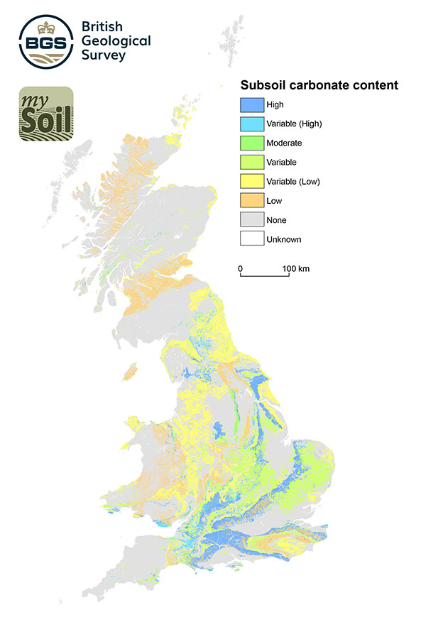
The Parent Material Carbonate Content classification is based on expert judgment of the likely content of CaCO3 in the total rock-mass of each parent material. Note that the map uses combinations of terms that refer to: High, Moderate, Low and Variable calcium carbonate content. As a rule of thumb, these categories are based on the bulk mineralogy of the parent material. For example, high carbonate content would be expected for a chalk or limestone parent material type; low carbonate content would be representative of weakly, calcite-cemented sandstone. The term variable is used where the parent material comprises two or more distinct lithologies e.g. interbedded limestone and mudstone where it is not possible to clearly identify the precise parent type at any given location. Users should note that land management practices and natural weathering processes of parent materials play a significant role in controlling carbonate content (it has not been possible to factor in these influences within the scope of this dataset) and so the classes shown in this dataset should be regarded as wholly 'indicative'.
| Title | Parent material carbonate content |
|---|---|
| Source | British Geological Survey |
| Enquiries | enquiries@bgs.ac.uk |
| Scale(s) | 1:50 000 and 1km grid resolution |
| Coverage | Great Britain |
| Format | GIS point data (ESRI, MapInfo, others available by request) |
| Price | 30p per km2 for commercial usesubject to licence fee and data preparation fee
The 1 km grid data is free for use under Open Government Licence terms |
| Uses | Local to national level use |
| Map Viewer | View in UKSO Map Viewer |
| WMS link | https://map.bgs.ac.uk/... |
| Images | High resolution |
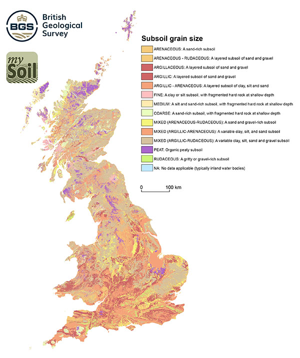
This is a generalized textural description of the Parent Material. The grain size values are derived from known sample measurements and expert judgement (based on field survey and description of the deposits). Where a parent material comprises more than one type of deposit a range of values is given. Deposits that are known to be heterolithic (i.e. consisting of a lithology comprising a wide range of grain sizes) are identified by the term 'mixed'. Note that geologists use different grain size descriptions for rocks derived from sedimentary and igneous origin. The following values are given in the dataset.
| Title | Subsoil grain size |
|---|---|
| Source | British Geological Survey |
| Enquiries | enquiries@bgs.ac.uk |
| Scale(s) | 1:50 000 and 1km grid resolution |
| Coverage | Great Britain |
| Format | GIS point data (ESRI, MapInfo, others available by request) |
| Price | 30p per km2 for commercial usesubject to licence fee and data preparation fee
The 1 km grid data is free for use under Open Government Licence terms |
| Uses | Local to national level use |
| Map Viewer | View in UKSO Map Viewer |
| WMS link | https://map.bgs.ac.uk/... |
| Images | High resolution |
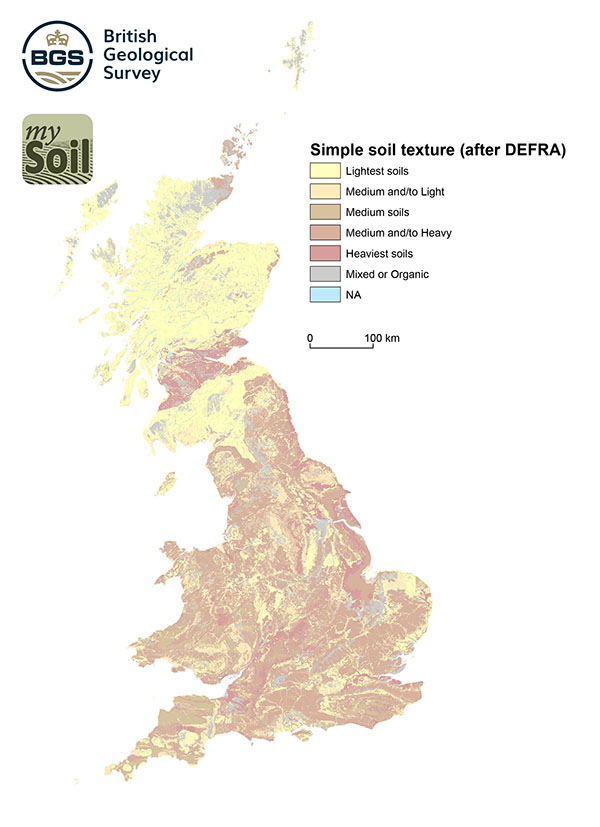
These generalised soil texture groupings are derived by comparing samples of measured soil textures (%clay, %silt and %sand) against a simplified soil grain-size ternary plot based on DEFRA: Cross Compliance Guidance for Soil Management 2006 and shown below. Note that this map uses terms that refer to Light soils (i.e. sand/silt rich), Medium soils (i.e. loams) and Heavy soils (i.e. clay rich). The classifications are based on analyses of archive GBase and geotechnical samples as well as expert judgment (where sample data is not available). Most parent materials generate a broad range of soil texture so these groupings should be regarded as 'indicative'. The 'Mixed or Organic' classification denotes highly variably textured soils or the presence of Peat (for which no texture data available).
| Title | Soil texture (simple) |
|---|---|
| Source | British Geological Survey |
| Enquiries | enquiries@bgs.ac.uk |
| Scale(s) | 1:50 000 and 1km grid resolution |
| Coverage | Great Britain |
| Format | GIS point data (ESRI, MapInfo, others available by request) |
| Price | 30p per km2 for commercial usesubject to licence fee and data preparation fee
The 1 km grid data is free for use under Open Government Licence terms |
| Uses | Local to national level use |
| Map Viewer | View in UKSO Map Viewer |
| WMS link | https://map.bgs.ac.uk/... |
| Images | High resolution |
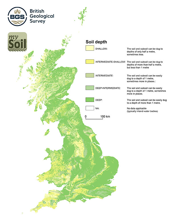
The simplified texture classifications are derived from measured soil thicknesses taken from archive borehole records held by BGS (see the BGS Soil-sample: Depth dataset in the map viewer). The thicknesses are compared and collated with the expected engineering strength classification of their underlying soil-parent material type to show a map of distribution of the classes; expert judgment has been used to estimate a thickness class where borehole data is not available). Note that the map uses combinations of terms that refer to: Deep soils, Intermediate soils and Shallow soils (see table below).
As a rule of thumb, these categories are based on the ability to manually dig (with a spade) without being hindered by a substrate that is too strong to excavate (i.e. layers of solid rock, dense gravel, or very stiff clays). An example of a deep soil would be one developed over unconsolidated, clayey Quaternary deposits, and an example of a shallow soil would be one found in areas underlain by chalk or limestone. Users should note that land management practices and natural weathering and accumulation (or erosion) processes of soil materials play a significant role in controlling soil thickness (it has not been possible to factor in these influences within the scope of this dataset) and so the classes shown in this dataset should be regarded as 'indicative'.
| Title | Simplified soil layer depth (thickness) |
|---|---|
| Source | British Geological Survey |
| Enquiries | enquiries@bgs.ac.uk |
| Scale(s) | 1:50 000 and 1km grid resolution |
| Coverage | Great Britain |
| Format | GIS point data (ESRI, MapInfo, others available by request) |
| Price | 30p per km2 for commercial usesubject to licence fee and data preparation fee
The 1 km grid data is free for use under Open Government Licence terms |
| Uses | Local to national level use |
| Map Viewer | View in UKSO Map Viewer |
| WMS link | https://map.bgs.ac.uk/... |
| Images | High resolution |
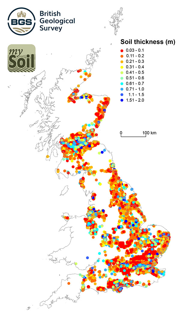
The BGS holds over a million borehole records and these can be viewed online in the dedicated borehole viewer. Coverage across Great Britain is clustered (generally within urban centres and corridors). This map only shows borehole data that has been captured to date (additional data may exist).
Boreholes are drilled for assessing ground conditions for construction, water and mineral resources. They are generally not drilled for the purpose of recording soil information. However, many boreholes note the depth of deposits classed as 'Topsoil' and so BGS has started to compile a dataset of reported 'Topsoil' depths. Most records suggest that the driller has identified a generic 'Topsoil' layer. Some records provide further details that indicate the topsoil layer has differing properties, or is not solely a topsoil layer but a combination of soil and other materials (e.g. parent material, peat and artificial ground). Users should therefore be aware that the term 'topsoil', as used in borehole records, should be regarded as a very simple description of what soil-scientists might regard as a combination of O, A, E and possibly B horizons.
| Title | Soil depth point data |
|---|---|
| Source | British Geological Survey |
| Enquiries | enquiries@bgs.ac.uk |
| Scale(s) | Point data (borehole-based) |
| Coverage | Great Britain |
| Format | GIS point data |
| Price | 30p per km2 for commercial usesubject to licence fee and data preparation fee
The 1 km grid data is free for use under Open Government Licence terms |
| Uses | Local to national level use |
| Map Viewer | View in UKSO Map Viewer |
| WMS link | https://map.bgs.ac.uk/... |
| Images | Point data |
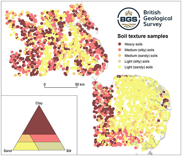
The map covers the Nottingham-Humberside and East Anglian G-Base survey areas only. The dataset comprises 2374 analyses from a subset of G-Base surface samples (0-20cm depth) taken at a density of 1 sample per 2km2.
The texture data was captured for a joint research project between BGS, Rothamsted Research and Nottingham University, looking at methods of estimating particle size from geochemical analyses of topsoil. The work was originally published in the European Journal of Soil Science as a paper entitled Estimating particle-size fractions of soil dominated by silicate minerals from geochemistry. The particle size analysis was carried out using laser granulometry and the data available in the viewer provides percentages (totalling 100%) of clay, silt and sand content. The map portrays the data in five simplified classes of soil. The European Soil Bureau code for the parent material underlying each sample is also provided.
| Title | Soil texture points |
|---|---|
| Source | British Geological Survey |
| Enquiries | enquiries@bgs.ac.uk |
| Scale(s) | 1:50 000 and 1km grid resolution |
| Coverage | Nottingham-Humberside and East Anglia |
| Format | GIS point data (ESRI, MapInfo, others available by request) |
| Price | 30p per km2 for commercial usesubject to licence fee and data preparation fee
The 1 km grid data is free for use under Open Government Licence terms |
| Uses | Local to national level use |
| Map Viewer | View in UKSO Map Viewer |
| WMS link | https://map.bgs.ac.uk/... |
| Images | Point data |
This is the European Soil Bureau (ESB) description used to identify each parent material type. The descriptions are taken from the Georeferenced Soil Database for Europe: Manual of Procedures Version 1.1. Each parent material type has been allocated to one (or more) ESB code on the basis of lithology, mode of origin or bulk chemistry.
The following broad ESB categories are represented by the geology of Great Britain.
| Title | ESB description of parent material |
|---|---|
| Source | British Geological Survey |
| Enquiries | enquiries@bgs.ac.uk |
| Scale(s) | 1:50 000 and 1km grid resolution |
| Coverage | Great Britain |
| Format | GIS point data (ESRI, MapInfo, others available by request) |
| Price | 30p per km2 for commercial usesubject to licence fee and data preparation fee
The 1 km grid data is free for use under Open Government Licence terms |
| Uses | Local to national level use |
| Map Viewer | View in UKSO Map Viewer |
| WMS link | https://map.bgs.ac.uk/... |
| Images | High resolution |