Select an option from the list below to view high resolution images and data about soils across England and Wales.
MAG–NET is an exciting five–year project aiming to develop novel, resilient, nutrient management strategies for the UK ruminant sector. The primary nutritional focus is magnesium (Mg) due to its strategic importance to the ruminant sector. However, new data, knowledge and communication tools arising from this project will apply to other nutrients / elements, thereby supporting more resilient production systems and improving our wider understanding of landscape–scale processes.
Magnesium (Mg) plays an important role in many basic processes in living cells, and is therefore essential for animal health. Low Mg status (hypomagnesaemia) gives rise to conditions called tetany, or staggers, in ruminants like cattle and sheep. These conditions are remarkably widespread among ruminants in Europe, often with high fatality rates. Avoiding hypomagnesaemia is therefore important for animal welfare and farm business profitability. Typically the condition is managed by use of feed mixes or dietary supplements or by directly administering Mg to animals as a medicine. However, these approaches are costly and can be inefficient and ineffective. Another approach is to ensure that the grass grazed by animals in the field or eaten as hay or silage provides a good source of Mg. This approach is under–developed in UK agriculture, as is forage fertiliser management.
We aim to develop novel and resilient nutrient management strategies for Mg in the UK ruminant sectors. The primary nutritional focus of this project is Mg due to its strategic importance to the UK ruminant sector. However, new data, knowledge and management and communication tools arising from this project will apply to other nutrients/elements which are important for animal health. The project will therefore have wider potential to make animal production more efficient and resilient and will improve our wider understanding of landscape-scale processes.
Plant–available soil magnesium (Mg) concentrations, in mg L‐1, are mapped for England and Wales. This layer is a prediction of concentrations derived from the combination of data from two separate soil fertility survey datasets.
The mapped data provides a national–scale overview of variation, but can also be interrogated to show fine–scale variation. Mg concentrations may be compared to the Mg Index values in the agricultural Nutrient Management Guide (RB209).
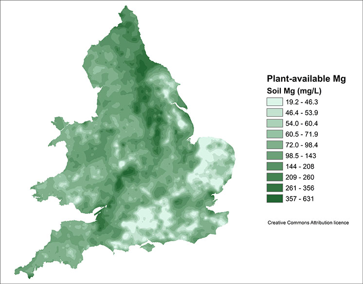
| Title | Plant–available soil magnesium concentrations |
|---|---|
| Source | Lark, RM, Ander, EL, Broadley, MR (2019) Combining two national-scale datasets to map soil properties, the case of available magnesium in England and Wales European Journal of Soil Science 70:361–377 |
| Enquiries | enquiries@bgs.ac.uk |
| Scale(s) | Prediction at 500m intervals converted to a continuous raster grid for UKSO |
| Coverage | England and Wales |
| Format | ESRI File Geodatabase Raster (FGDBR) or points |
| Price | Free for use. Creative Commons Attribution |
| Uses | Local to national level use |
| UKSO map viewer | View in UKSO Map Viewer |
| WMS | https://map.bgs.ac.uk/... |
| Image(s) | High resolution | Low resolution |
The probability that plant–available Mg concentration in soil is below RB209 Index 2, i.e. <51 mg L‐1, is presented here using a combination of colour, numerical (percentage) and verbal scales to communicate the uncertainty of this outcome.
These probabilities are obtained from the combined statistical analysis of two national-scale data sets on soil chemical properties.
The scales to present the uncertainties follow the IPCC guidelines for communicating uncertain information with "calibrated phrases", Mastrandrea et al., 2010 (https://archive.ipcc.ch/pdf/supporting-material/uncertainty-guidance-note.pdf), modified, as described by Lark et al (2019) in the references below, to reflect the findings of psychological studies on how such scales are interpreted.
This map will allow users better to understand the uncertainty in the predicted soil concentrations of plant-available Mg, understood in comparison with the Index 2 threshold for which there are soil fertility management recommendations in the Nutrient Management Guide (RB209) published by AHDB.
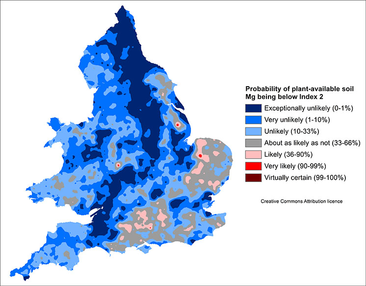
| Title | Probability that soil available–Mg is below RB209 Index 2 |
|---|---|
| Source | Lark, RM, Ander, EL, Broadley, MR (2019) Combining two national-scale datasets to map soil properties, the case of available magnesium in England and Wales European Journal of Soil Science 70:361–377 |
| Enquiries | enquiries@bgs.ac.uk |
| Scale(s) | Prediction at 500m intervals converted to a continuous raster grid for UKSO |
| Coverage | England and Wales |
| Format | ESRI File Geodatabase Raster (FGDBR) or points |
| Price | Free for use. Creative Commons Attribution |
| Uses | Local to national level use |
| UKSO map viewer | View in UKSO Map Viewer |
| WMS | https://map.bgs.ac.uk/... |
| Image(s) | High resolution | Low resolution |