Select an option from the list below to view high resolution images and data about soils across Great Britain.
Users of the UKSO and the mySoil mobile app are engaging in citizen science to validate the Centre for Ecology & Hydrology (CEH) land cover map. They are crowdsourcing information about the accuracy of the land cover map by using either their local knowledge or by comparing the provided land cover type classification to aerial photography. The collected data will be stored and used to improve the accuracy of the dataset.
For a given point location, users indicate whether the land cover map presents the correct land cover type. Where they believe it is incorrect, they submit a corrected value. Users are also encouraged to submit photographs.
Land Cover Map 2015 (LCM2015), released in April 2017, is the land cover map from the Centre for Ecology & Hydrology. It is derived from satellite images and digital cartography and gives land cover information for the entire UK. Land cover is based on UK Biodiversity Action Plan Broad Habitats.
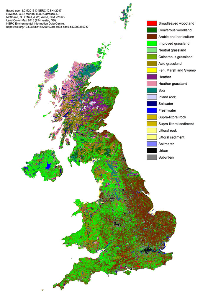
| Title | CEH Land Cover Map 2015 |
|---|---|
| Source | Centre for Ecology & Hydrology |
| Enquiries | eidc@ceh.ac.uk |
| Scale(s) | Vector data scale: Minimum Mappable Unit for land cover parcels: 0.5ha
Raster data scale: 25m and 1km pixel size |
| Coverage | Great Britain |
| Format | Vector and raster available |
| Price | See https://www.ceh.ac.uk/... for details |
| Uses | Local to national level use |
| Map Viewer | View in UKSO Map Viewer |
| WMS link | https://catalogue.ceh.ac.uk/... |
| Images | High resolution | low resolution |
This map presents crowdsourced data validating the CEH Land Cover Map 2015 from users of the UK Soil Observatory and the mySoil mobile app. This citizen science dataset focuses on the United Kingdom.
Points on the map indicate locations where records validating the CEH Land Cover Map 2015 have been submitted. Links through to access these records and any photographs are provided.
It is hoped that these crowdsourced records can be used to validate and improve our own data holdings and lead to the creation of new community data products.
This crowdsourced CEH Land Cover Map 2015 validation data is licensed under the Open Government Licence.
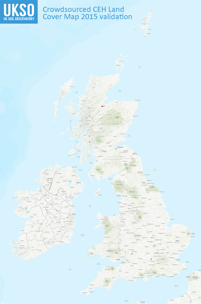
| Title | Crowdsourced CEH Land Cover Map 2015 validation |
|---|---|
| Source | UKSO and mySoil user community |
| Enquiries | enquiries@bgs.ac.uk |
| Scale(s) | Point data |
| Coverage | Great Britain |
| Format | GIS spatial point data |
| Price | Free via the mySoil app |
| Uses | Local to national level use |
| Map Viewer | View in UKSO Map Viewer |
| WMS link | https://map.bgs.ac.uk/... |
| Images | High resolution | low resolution |
Land Cover Map 2007 (LCM2007), released in July 2011, is the land cover map from the Centre for Ecology & Hydrology. It is derived from satellite images and digital cartography and gives land cover information for the entire UK. Land cover is based on UK Biodiversity Action Plan Broad Habitats.
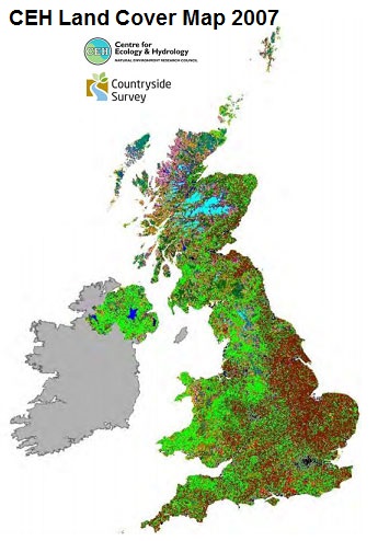
| Title | CEH Land Cover Map 2007 |
|---|---|
| Source | Centre for Ecology & Hydrology |
| Enquiries | eidc@ceh.ac.uk |
| Scale(s) | Vector data scale: Minimum Mappable Unit for land cover parcels: 0.5ha
Raster data scale: 25m and 1km pixel size |
| Coverage | Great Britain |
| Format | Vector and raster available |
| Price | See https://www.ceh.ac.uk/... for details |
| Uses | Local to national level use |
| Map Viewer | View in UKSO Map Viewer |
| WMS link | https://catalogue.ceh.ac.uk/... |
| Images | High resolution | low resolution |
This map presents crowdsourced data validating the CEH Land Cover Map 2007 from users of the UK Soil Observatory and the mySoil mobile app. This citizen science dataset focuses on the United Kingdom.
Points on the map indicate locations where records validating the CEH Land Cover Map 2007 have been submitted. Links through to access these records and any photographs are provided.
It is hoped that these crowdsourced records can be used to validate and improve our own data holdings and lead to the creation of new community data products.
This crowdsourced CEH Land Cover Map 2007 validation data is licensed under the Open Government Licence.
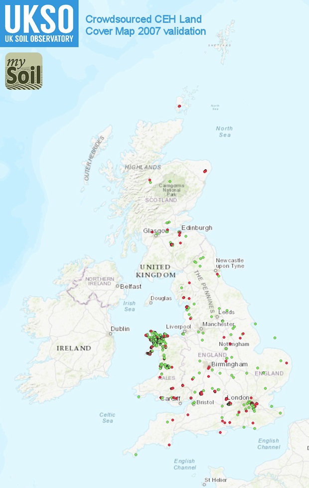
| Title | Crowdsourced CEH Land Cover Map 2007 validation |
|---|---|
| Source | UKSO and mySoil user community |
| Enquiries | enquiries@bgs.ac.uk |
| Scale(s) | Point data |
| Coverage | Great Britain |
| Format | GIS spatial point data |
| Price | Free via the mySoil app |
| Uses | Local to national level use |
| Map Viewer | View in UKSO Map Viewer |
| WMS link | https://map.bgs.ac.uk/... |
| Images | High resolution | low resolution |