Select an option from the list below to view high resolution images and data about soils across Great Britain.
The BGS Geochemical Baseline Survey of the Environment (G-BASE) is a national geochemical mapping programme of Great Britain. The G-BASE project set out to survey the chemistry of the surface environment by the collection and analysis of stream sediment, stream water and soil samples.
Beginning in the late 1960s in northern Scotland, and moving southwards across the country, the primary focus was mineral exploration, however, the project quickly developed to address important environmental concerns. The final G-BASE samples were collected in southern England in 2014.
The outputs from the G-BASE project provide an invaluable systematic baseline of geochemical information for Great Britain, serving as a marker of the state of the environment, against which to measure future change.
Soil samples were collected by hand auger, from two depths - 5 to 20 cm (shallow soil) and 35 to 50 cm (deep soil) at an average density of 1 every 2 km2 in regional environments. In urban areas, samples were collected at a higher density of 4 samples per 1 km2.
Samples have been collected over large areas of England and Wales, the Clyde Basin in Scotland, and from 23 urban centres across Great Britain. From the resulting samples, geochemical data are available for over 50 inorganic analytes.
The largest urban centre sampled is London, with samples collected within the entire area of the Greater London Authority boundary. The 'London Earth' project stands as a sub-set of the overall G-BASE project.
Most recently, a series of maps presenting the shallow soil chemistry of South West England have been published.
G-BASE soil data are delivered under the terms of the Open Government Licence, subject to the following acknowledgement accompanying the reproduced BGS materials: "Contains British Geological Survey materials © [2021]".
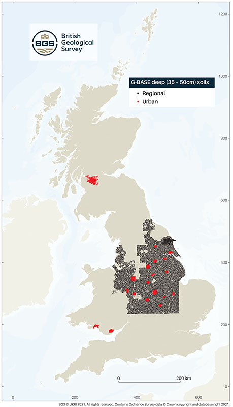
G-BASE deep soil data are available from a limited regional coverage of England and Wales and from a number of urban centres.
Deep soils were sieved to <150µm before being prepared for analysis. Samples collected over North East England, between 1986 and 1988, were analysed by the method of optical emission spectroscopy (OES). All subsequent samples (1989 to 2002) were analysed by x-ray fluorescence spectrometry (XRFS). Samples were analysed for up to 48 inorganic analytes. Whilst deep soil samples continued to be collected for a period after 2002, including the London Earth project, these samples were not routinely analysed.
G-BASE samples were collected at a density of 1 sample per two square kilometres of the British National Grid in regional areas, and 4 samples every 1km2 in urban areas.
| Title | G-BASE profile soil (points) |
|---|---|
| Source | British Geological Survey |
| Enquiries | enquiries@bgs.ac.uk |
| Scale(s) | Point data |
| Coverage | Great Britain |
| Format | GIS point data |
| Price | A free WMS service is available (see below) |
| Uses | Local to national level use |
| Map Viewer | View in UKSO Map Viewer |
| WMS link | https://map.bgs.ac.uk/... |
| Images |
GBASE deep soil .svg format (vector)
GBASE deep soil .pdf format (vector) GBASE deep soil .jpg format (raster) |
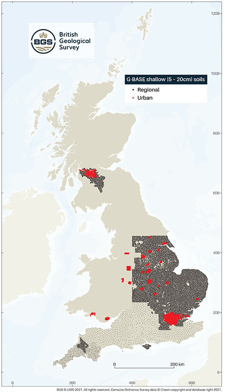
G-BASE shallow soil data are available from a limited regional coverage of England and Scotland, and from a number of urban centres.
Shallow soils were sieved to <2mm before being prepared for analysis. All shallow soil samples (1993 to 2014) were analysed by x-ray fluorescence spectrometry (XRFS). Samples were analysed for up to 51 inorganic analytes.
G-BASE samples were initially collected at a density of 1 sample per two square kilometres of the British National Grid in regional areas.
In southern England, an alternative, statistically based sampling strategy was adopted to ensure representative coverage.
In urban areas, 4 samples were collected in every 1km2.
| Title | G-BASE topsoil (points) |
|---|---|
| Source | British Geological Survey |
| Enquiries | enquiries@bgs.ac.uk |
| Scale(s) | Point data |
| Coverage | Great Britain |
| Format | GIS point data |
| Price | A free WMS service is available (see below) |
| Uses | Local to national level use |
| Map Viewer | View in UKSO Map Viewer |
| WMS link | https://map.bgs.ac.uk/... |
| Image download |
GBASE shallow soil .svg format (vector)
GBASE shallow soil .pdf format (vector) GBASE shallow soil .jpg format (raster) |