Select an option from the list below to view high resolution images and data about soils across Great Britain.
The BioSoil survey in the UK was led by Forest Research and there are 167 BioSoil plots on a 16km x 16km grid in the UK, of which 125 are on private woodland and 42 on Forestry Commission woodland. All 167 plots have been surveyed and field information and soil description (according to the World Reference Base soil classification, WRB, 2006) gathered in addition to soil sampling for chemical analysis.
Soil samples were processed and are being analysed by Forest Research chemical analysis laboratory. The BioSoil soil analysis include pH, soil organic carbon, soil inorganic carbon, total nitrogen, base cations and heavy metals, bulk density and fragment content at 0-5, 5-10, 10-20, 20-40 and 40-80cm of the soil profile. In addition, forest floor layers (L-litter, F-fermentation layer and H – humification layer) in each plot were samples and analysed for carbon, nitrogen, nutrients and heavy metals.
Information based on database BioSoil – Crown copyright - organisation Forest Research.
These data are delivered under the terms of the Open Government Licence, subject to the following acknowledgement accompanying the reproduced FR-BioSoil materials: "Contains Forest Research BioSoil survey data © [2014]".
The map covers Great Britain’s BioSoil plot pH data for the top 0-5cm of the soil. The BioSoil Soil pH 0-5cm point data are derived from 167 BioSoil plots under forest and pH measured in soil water in ratio of 1:20.

| Title | Forest Research BioSoil project - pH at 0-5cm |
|---|---|
| Source | Forest Research |
| Enquiries | elena.vanguelova@forestry.gsi.gov.uk |
| Scale(s) | Plot Scale |
| Coverage | Great Britain |
| Format | GIS spatial point data |
| Price | Data is free for none commercial purpose and under data sharing licence |
| Uses | Local to national level use |
| Map Viewer | View in UKSO Map Viewer |
| WMS link | https://map.bgs.ac.uk/... |
| Images | High resolution | low resolution |
The map covers Great Britain’s BioSoil plot pH data for the top 5-10cm of the soil. The BioSoil Soil pH 5-10cm point data are derived from 167 BioSoil plots under forest and pH measured in soil water in ratio of 1:20.
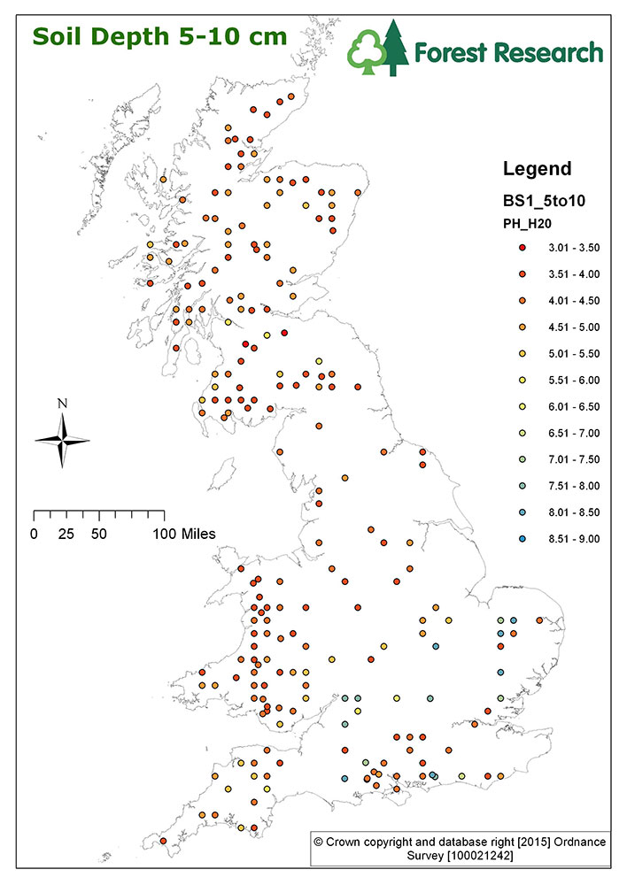
| Title | Forest Research BioSoil project - pH at 5-10cm |
|---|---|
| Source | Forest Research |
| Enquiries | elena.vanguelova@forestry.gsi.gov.uk |
| Scale(s) | Plot Scale |
| Coverage | Great Britain |
| Format | GIS spatial point data |
| Price | Data is free for none commercial purpose and under data sharing licence |
| Uses | Local to national level use |
| Map Viewer | View in UKSO Map Viewer |
| WMS link | https://map.bgs.ac.uk/... |
| Images | High resolution | low resolution |
The map covers Great Britain’s BioSoil plot pH data for the top 10-20cm of the soil. The BioSoil Soil pH 10-20cm point data are derived from 167 BioSoil plots under forest and pH measured in soil water in ratio of 1:20.

| Title | Forest Research BioSoil project - pH at 10-20cm |
|---|---|
| Source | Forest Research |
| Enquiries | elena.vanguelova@forestry.gsi.gov.uk |
| Scale(s) | Plot Scale |
| Coverage | Great Britain |
| Format | GIS spatial point data |
| Price | Data is free for none commercial purpose and under data sharing licence |
| Uses | Local to national level use |
| Map Viewer | View in UKSO Map Viewer |
| WMS link | https://map.bgs.ac.uk/... |
| Images | High resolution | low resolution |
The map covers Great Britain’s BioSoil plot pH data for the top 20-40cm of the soil. The BioSoil Soil pH 20-40cm point data are derived from 167 BioSoil plots under forest and pH measured in soil water in ratio of 1:20.
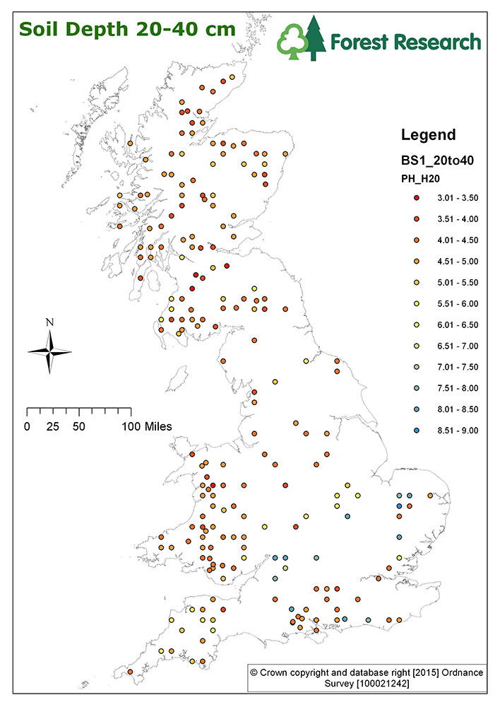
| Title | Forest Research BioSoil project - pH at 20-40cm |
|---|---|
| Source | Forest Research |
| Enquiries | elena.vanguelova@forestry.gsi.gov.uk |
| Scale(s) | Plot Scale |
| Coverage | Great Britain |
| Format | GIS spatial point data |
| Price | Data is free for none commercial purpose and under data sharing licence |
| Uses | Local to national level use |
| Map Viewer | View in UKSO Map Viewer |
| WMS link | https://map.bgs.ac.uk/... |
| Images | High resolution | low resolution |
The map covers Great Britain’s BioSoil plot pH data for the top 40-80cm of the soil. The BioSoil Soil pH 40-80cm point data are derived from 167 BioSoil plots under forest and pH measured in soil water in ratio of 1:20.
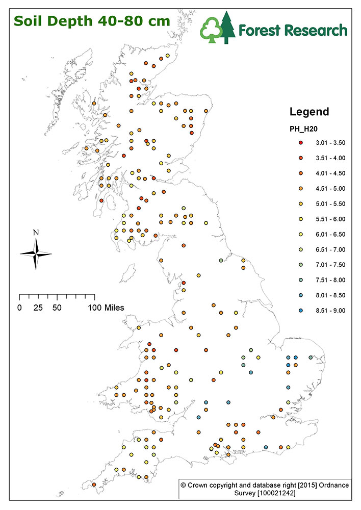
| Title | Forest Research BioSoil project - pH at 40-80cm |
|---|---|
| Source | Forest Research |
| Enquiries | elena.vanguelova@forestry.gsi.gov.uk |
| Scale(s) | Plot Scale |
| Coverage | Great Britain |
| Format | GIS spatial point data |
| Price | Data is free for none commercial purpose and under data sharing licence |
| Uses | Local to national level use |
| Map Viewer | View in UKSO Map Viewer |
| WMS link | https://map.bgs.ac.uk/... |
| Images | High resolution | low resolution |
The map covers Great Britain’s BioSoil plot CS data for the top 0-5cm of the soil. The BioSoil Soil CS 0-5cm point data are derived from 167 BioSoil plots under forest and C stocks calculated from measured soil C concentrations, measured bulk density and fragment content.
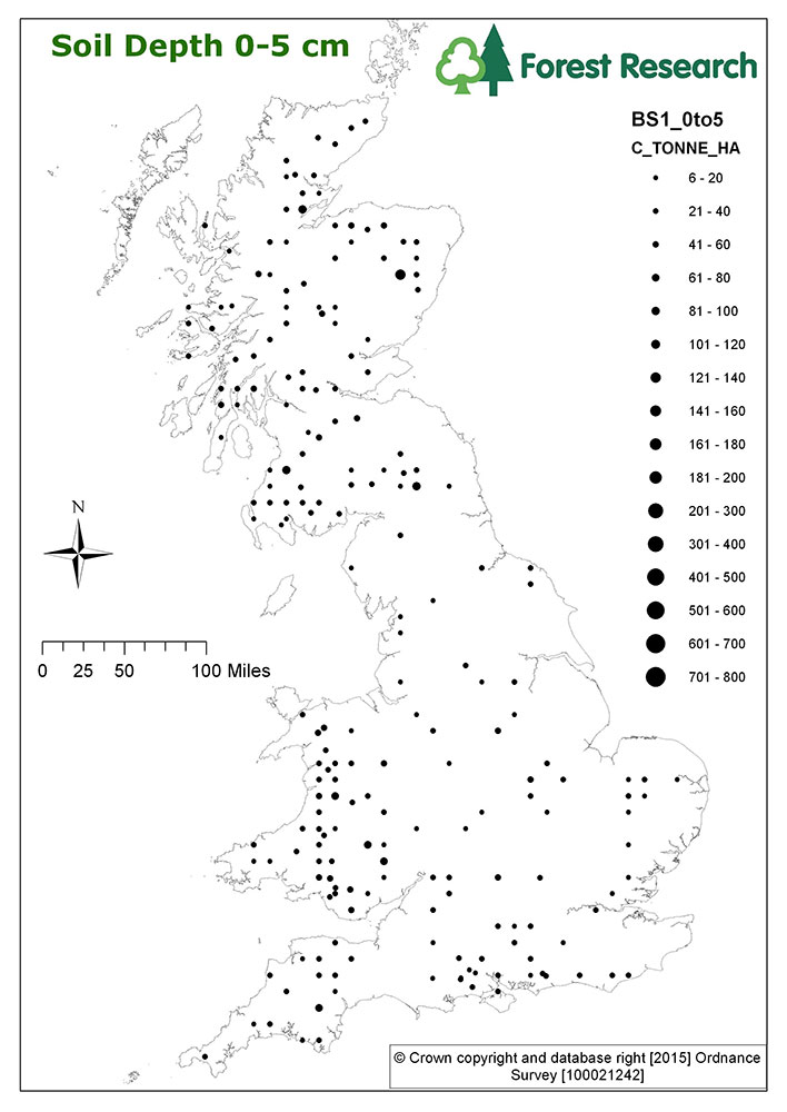
| Title | Forest Research BioSoil project - CS at 0-5cm |
|---|---|
| Source | Forest Research |
| Enquiries | elena.vanguelova@forestry.gsi.gov.uk |
| Scale(s) | Plot Scale |
| Coverage | Great Britain |
| Format | GIS spatial point data |
| Price | Data is free for none commercial purpose and under data sharing licence |
| Uses | Local to national level use |
| Map Viewer | View in UKSO Map Viewer |
| WMS link | https://map.bgs.ac.uk/... |
| Images | High resolution | low resolution |
The map covers Great Britain’s BioSoil plot CS data for the top 5-10cm of the soil. The BioSoil Soil CS 5-10cm point data are derived from 167 BioSoil plots under forest and C stocks calculated from measured soil C concentrations, measured bulk density and fragment content.

| Title | Forest Research BioSoil project - CS at 5-10cm |
|---|---|
| Source | Forest Research |
| Enquiries | elena.vanguelova@forestry.gsi.gov.uk |
| Scale(s) | Plot Scale |
| Coverage | Great Britain |
| Format | GIS spatial point data |
| Price | Data is free for none commercial purpose and under data sharing licence |
| Uses | Local to national level use |
| Map Viewer | View in UKSO Map Viewer |
| WMS link | https://map.bgs.ac.uk/... |
| Images | High resolution | low resolution |
The map covers Great Britain’s BioSoil plot CS data for the top 10-20cm of the soil. The BioSoil Soil CS 10-20cm point data are derived from 167 BioSoil plots under forest and C stocks calculated from measured soil C concentrations, measured bulk density and fragment content.
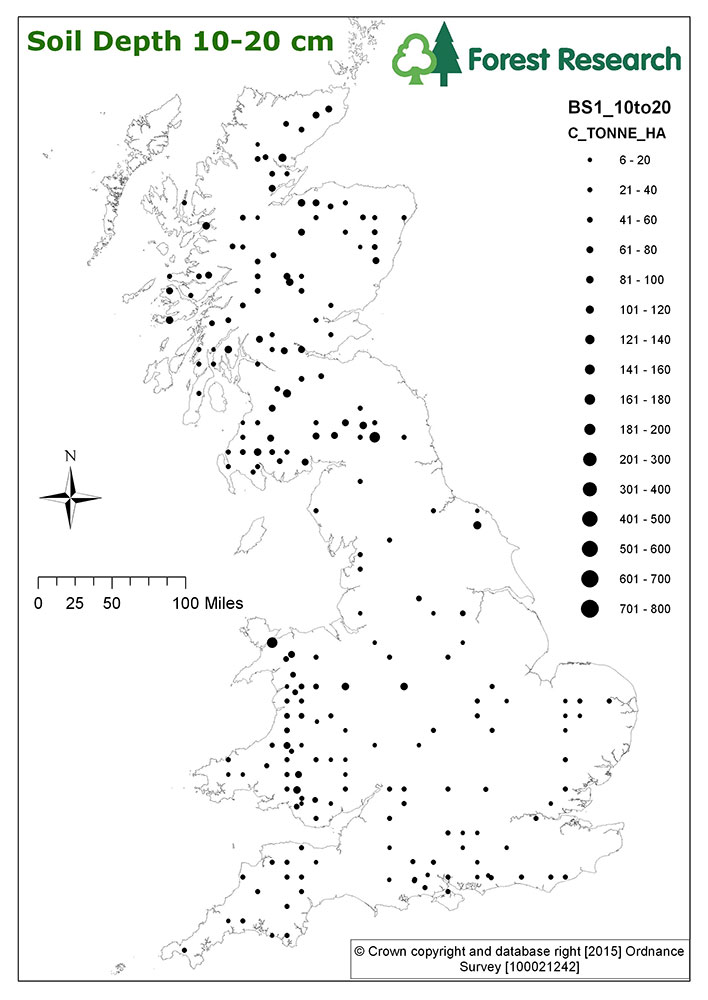
| Title | Forest Research BioSoil project - CS at 10-20cm |
|---|---|
| Source | Forest Research |
| Enquiries | elena.vanguelova@forestry.gsi.gov.uk |
| Scale(s) | Plot Scale |
| Coverage | Great Britain |
| Format | GIS spatial point data |
| Price | Data is free for none commercial purpose and under data sharing licence |
| Uses | Local to national level use |
| Map Viewer | View in UKSO Map Viewer |
| WMS link | https://map.bgs.ac.uk/... |
| Images | High resolution | low resolution |
The map covers Great Britain’s BioSoil plot CS data for the top 20-40cm of the soil. The BioSoil Soil CS 20-40cm point data are derived from 167 BioSoil plots under forest and C stocks calculated from measured soil C concentrations, measured bulk density and fragment content.
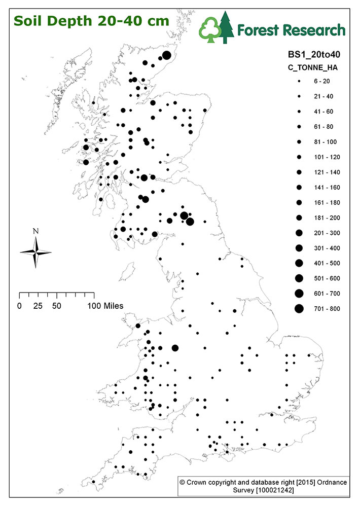
| Title | Forest Research BioSoil project - CS at 20-40cm |
|---|---|
| Source | Forest Research |
| Enquiries | elena.vanguelova@forestry.gsi.gov.uk |
| Scale(s) | Plot Scale |
| Coverage | Great Britain |
| Format | GIS spatial point data |
| Price | Data is free for none commercial purpose and under data sharing licence |
| Uses | Local to national level use |
| Map Viewer | View in UKSO Map Viewer |
| WMS link | https://map.bgs.ac.uk/... |
| Images | High resolution | low resolution |
The map covers Great Britain’s BioSoil plot CS data for the top 40-80cm of the soil. The BioSoil Soil CS 40-80cm point data are derived from 167 BioSoil plots under forest and C stocks calculated from measured soil C concentrations, measured bulk density and fragment content.
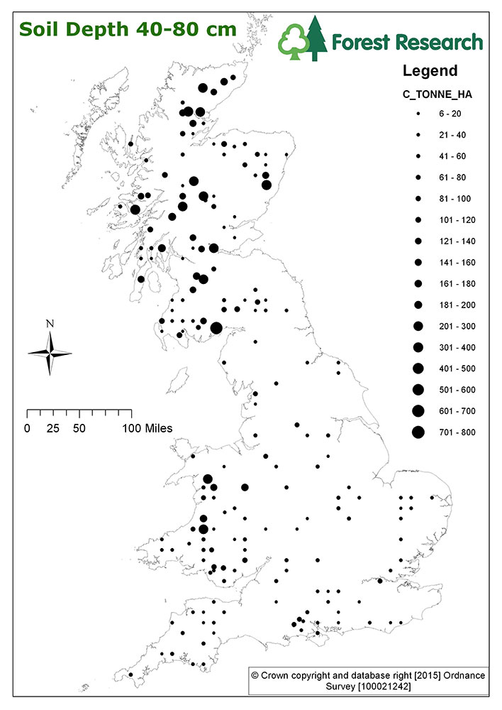
| Title | Forest Research BioSoil project - CS at 40-80cm |
|---|---|
| Source | Forest Research |
| Enquiries | elena.vanguelova@forestry.gsi.gov.uk |
| Scale(s) | Plot Scale |
| Coverage | Great Britain |
| Format | GIS spatial point data |
| Price | Data is free for none commercial purpose and under data sharing licence |
| Uses | Local to national level use |
| Map Viewer | View in UKSO Map Viewer |
| WMS link | https://map.bgs.ac.uk/... |
| Images | High resolution | low resolution |
The map covers Great Britain’s BioSoil plot TOC data for the top 0-5cm of the soil. The BioSoil Soil TOC 0-5cm point data are derived from 167 BioSoil plots under forest and C stocks calculated from measured soil C concentration measured by total C/N analyser by combustion.
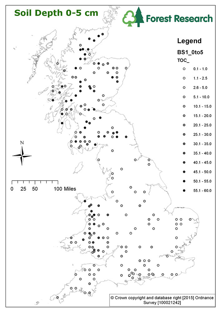
| Title | Forest Research BioSoil project - TOC at 0-5cm |
|---|---|
| Source | Forest Research |
| Enquiries | elena.vanguelova@forestry.gsi.gov.uk |
| Scale(s) | Plot Scale |
| Coverage | Great Britain |
| Format | GIS spatial point data |
| Price | Data is free for none commercial purpose and under data sharing licence |
| Uses | Local to national level use |
| Map Viewer | View in UKSO Map Viewer |
| WMS link | https://map.bgs.ac.uk/... |
| Images | High resolution | low resolution |
The map covers Great Britain’s BioSoil plot TOC data for the top 5-10cm of the soil. The BioSoil Soil TOC 5-10cm point data are derived from 167 BioSoil plots under forest and C stocks calculated from measured soil C concentration measured by total C/N analyser by combustion.
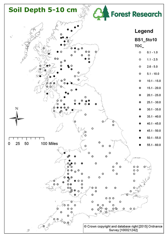
| Title | Forest Research BioSoil project - TOC at 5-10cm |
|---|---|
| Source | Forest Research |
| Enquiries | elena.vanguelova@forestry.gsi.gov.uk |
| Scale(s) | Plot Scale |
| Coverage | Great Britain |
| Format | GIS spatial point data |
| Price | Data is free for none commercial purpose and under data sharing licence |
| Uses | Local to national level use |
| Map Viewer | View in UKSO Map Viewer |
| WMS link | https://map.bgs.ac.uk/... |
| Images | High resolution | low resolution |
The map covers Great Britain’s BioSoil plot TOC data for the top 10-20cm of the soil. The BioSoil Soil TOC 10-20cm point data are derived from 167 BioSoil plots under forest and C stocks calculated from measured soil C concentration measured by total C/N analyser by combustion.

| Title | Forest Research BioSoil project - TOC at 10-20cm |
|---|---|
| Source | Forest Research |
| Enquiries | elena.vanguelova@forestry.gsi.gov.uk |
| Scale(s) | Plot Scale |
| Coverage | Great Britain |
| Format | GIS spatial point data |
| Price | Data is free for none commercial purpose and under data sharing licence |
| Uses | Local to national level use |
| Map Viewer | View in UKSO Map Viewer |
| WMS link | https://map.bgs.ac.uk/... |
| Images | High resolution | low resolution |
The map covers Great Britain’s BioSoil plot TOC data for the top 20-40cm of the soil. The BioSoil Soil TOC 20-40cm point data are derived from 167 BioSoil plots under forest and C stocks calculated from measured soil C concentration measured by total C/N analyser by combustion.
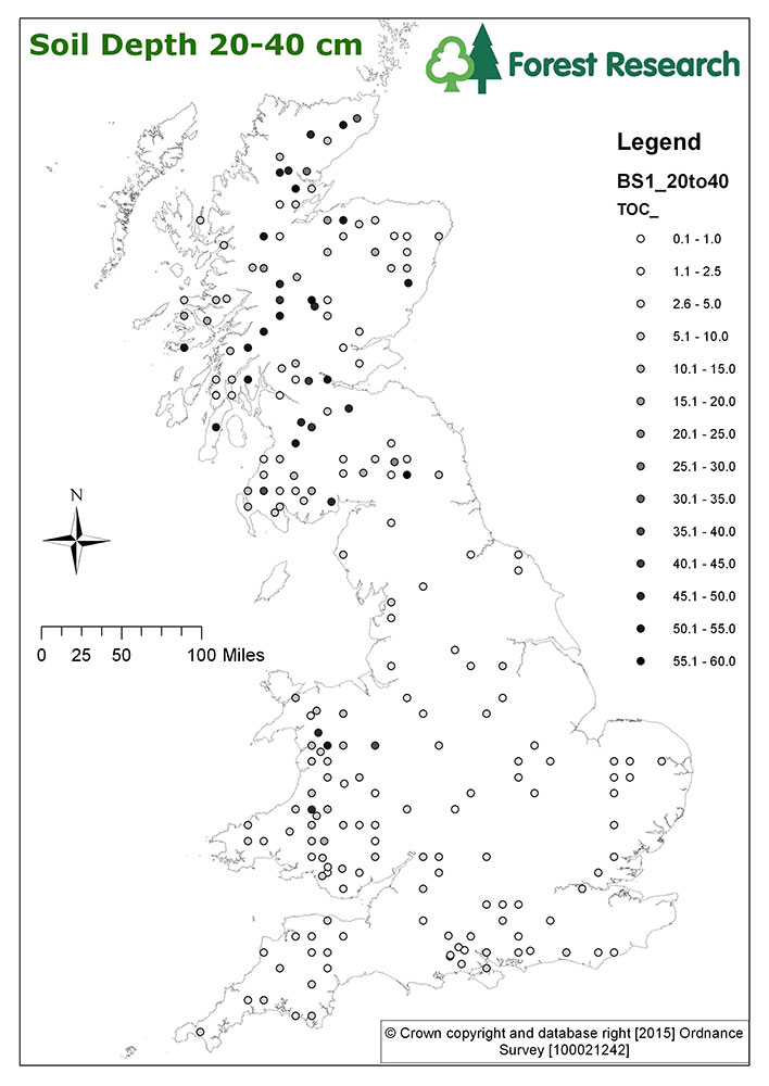
| Title | Forest Research BioSoil project - TOC at 20-40cm |
|---|---|
| Source | Forest Research |
| Enquiries | elena.vanguelova@forestry.gsi.gov.uk |
| Scale(s) | Plot Scale |
| Coverage | Great Britain |
| Format | GIS spatial point data |
| Price | Data is free for none commercial purpose and under data sharing licence |
| Uses | Local to national level use |
| Map Viewer | View in UKSO Map Viewer |
| WMS link | https://map.bgs.ac.uk/... |
| Images | High resolution | low resolution |
The map covers Great Britain’s BioSoil plot TOC data for the top 40-80cm of the soil. The BioSoil Soil TOC 40-80cm point data are derived from 167 BioSoil plots under forest and C stocks calculated from measured soil C concentration measured by total C/N analyser by combustion.
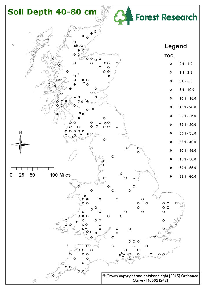
| Title | Forest Research BioSoil project - TOC at 40-80cm |
|---|---|
| Source | Forest Research |
| Enquiries | elena.vanguelova@forestry.gsi.gov.uk |
| Scale(s) | Plot Scale |
| Coverage | Great Britain |
| Format | GIS spatial point data |
| Price | Data is free for none commercial purpose and under data sharing licence |
| Uses | Local to national level use |
| Map Viewer | View in UKSO Map Viewer |
| WMS link | https://map.bgs.ac.uk/... |
| Images | High resolution | low resolution |