Select an option from the list below to view high resolution images and data about soils across England and Wales.
The addition of lime can improve soil conditions for the growth of forage for ruminate animals by providing optimal pH conditions. Also, alongside the reduction of soil acidity, the application of magnesium-rich agricultural lime products can help to ensure pasture forage contains sufficient magnesium to avoid hypomagnesaemia in livestock.
This is a regional level dataset designed for rapid desk based assessments and should not be used as a substitute for local level ground investigations.
Based upon:
This work was funded jointly by the Biotechnology and Biological Sciences Research Council and the Natural Environment Research Council under The Sustainable Agriculture research & Innovation Club (SARIC), and was carried out as part of a collaborative project of the University of Nottingham, British Geological Survey, Aberystwyth University, Germinal Holdings Limited, Origin Fertilisers, XL Vet UK Limited and Yara UK Limited.
These data are delivered under the terms of the Open Government Licence, subject to the following acknowledgement accompanying the reproduced BGS materials: "Contains British Geological Survey materials © UKRI [year]".
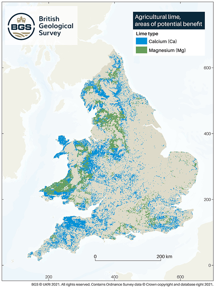
This dataset shows areas in England and Wales where it may be beneficial to apply agricultural lime, and if so, whether calcium (Ca) or magnesium (Mg) rich limestone are the most appropriate products.
Data from four datasets have been combined to create a tool to give easily accessible information to help in decisions to identify the most effective soil improvement techniques. datasets used are soil pH, land use (to delineate areas of grassland appropriate for liming) (both based on digital spatial data licensed from the UK Centre for Ecology & Hydrology), soil texture and soil Mg availability (based on BGS data).
The full methodology outlining how this data set has been constructed, sources of component datasets used and how it can be used are given in Bide et al., 2021. A spatial analysis of lime resources and their potential for improving soil magnesium concentrations and pH in grassland areas of England and Wales.
| Title | Agricultural lime, areas of potential benefit |
|---|---|
| Source | British Geological Survey |
| Enquiries | enquiries@bgs.ac.uk |
| Scale(s) | Complied from a combination of 1:50 000 geological mapping and 1km gridded data |
| Coverage | England and Wales |
| Format | GIS polygon data |
| Price | Free for use through Open Government Licence with attribution statement |
| Uses | Local to national level use |
| UKSO map viewer | View in UKSO Map Viewer |
| WMS | https://map.bgs.ac.uk/... |
| Image(s) |
Agricultural lime .pdf format (vector)
Agricultural lime .jpg format (raster) |